

Wacke...............................................................................................................................................................................................................................................................Wacke
Wacke (arenito sujo) / Wacke (piedra arenisca sucio) / Wacke (schmutzig Sandstein) / Wacke (脏砂岩) / Граувакка (грязный песчаник) / Wacke (arenaria sporca) /
In mineralogy, an opaque material between basalt and a clayey rock. As a rock type, a wacke is a little-graded sandstone, i.e., a mixture of sand, silt, and clay. A graywacke (turbidite) is a special wacke type.
See: « Beach Rock »
&
« Turbidite »
&
« Graywacke »
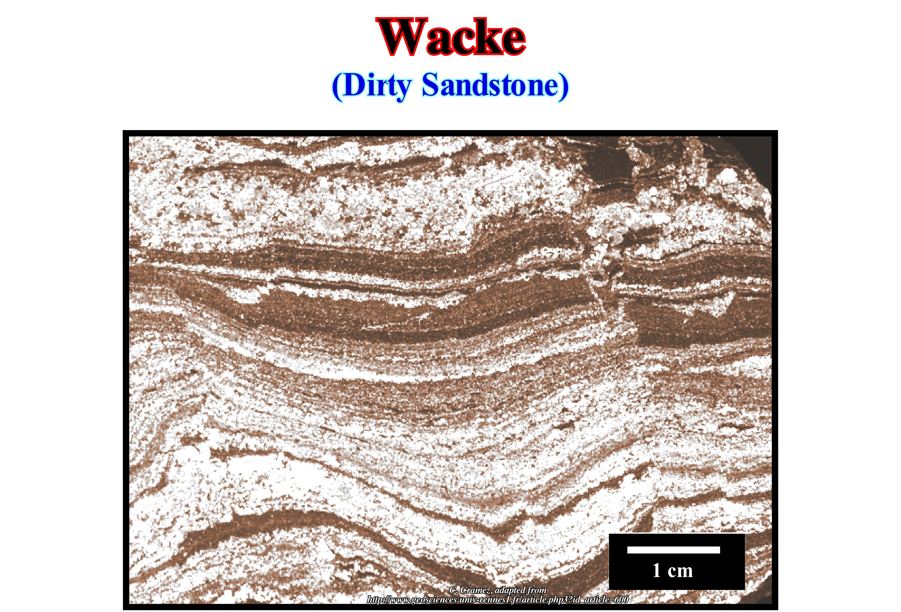
As illustrated in this figure a wacke, as all sandstones contain quartz, but also other minerals and even small fragments of rock. A wacke is what some Anglo-Saxon geoscientists call dirty sandstone, which they define as a sedimentary rock composed of sand grains, medium size, between 0.06 to 2 mm and with a, relatively, thin clay matrix. The grains of sand are very different from the rock fragments. The presence of pyroxenes, amphiboles, feldspar, mica, etc. is widespread. The grains are angular and misclassified, with many minerals that still maintain, forms of growth, which suggests a little abrasion and weathering. The matrix, which contains considerable amounts of clay minerals, can form up to 50 percent by volume. The clay minerals, chlorite and biotite are more abundant than muscovite and illite (kaolinite is almost always absent). The graywacke is a particular type of wacke, taking into account its origin, composition and texture (very special). The term graywacke was the name that the German miners of Harz (central Germany, Saxony) used to describe ore-less veins that were described as a Paleozoic sandstone of grey colour dark green, very hardened and very rich in fragments of other rocks and with a compact clayey matrix. A graywacke lies in the deepest parts of the sedimentary basins, not far from the mountain ranges. Rivers and mountain chains water-courses carry coarse sedimentary particles, relatively, fresh (not calibrated), since transport is quite fast and relatively small. When this type of sedimentary influx reaches the shoreline, particularly in the basins without shelf, the material is transported to the deeper parts of the basin by turbidite currents (induced by relative sea level falls and river floodings) where it is deposited under the form of turbidite fans.
Wackestone........................................................................................................................................................................................................................Wackstone
Wackestone / Wackestone / Wackestone (mehr als 10 % allochems) / 灰岩 / Вакстоун / Wackestone (più del 10% allochems) /
Carbonate rock consisting of noncontiguous elements bounded to at least 10% by finely crystallized cement (classification by R.J. Dunham).
See: « Calcarenite »
&
« Deposition (carbonates) »
&
« Precipitation (chemistry) »

The great structures of the carbonates can be described according to the textural composition, which according to the classification of Folk are: (i) Intraclasts, that is, fragments of contemporary carbonated sediments ; (ii) Pellets, i.e., spherical particles less than 0.2 mm of cryptocrystalline limestone, generally, rich in organic matter (often of faecal origin) ; (iii) Oolites, i.e., small spheres with a diameter between 0.5 and 2 mm, whose centre is a detrital particle and whose envelope is made of thin layers, which give it a more or less concentric structure ; (iv) Bioclasts, i.e., any complete or partial fossil element (fragment) of animal or plant origin, whether transported or not. All of these textures are a function of the depositional environment, fauna and flora present at the time of deposition and the agitation of the environment. They can be combined between them and the matrix in various ways, defined by the Dunham classification: (A) Boundstone (limestone built), when the organic components are bonded between them during the deposition ; (B) When organic components are not bonded together during deposition, the following possibilities may be differentiated: (B1) Grainstone, in the absence of fine particles ; (B2) Packstone in the presence of fine particles and if the beans are contiguous; (B3) Wackstone, in the absence of fine particles, but when the grains are not contiguous and with less than 20% of mud ; (B4) Mudstone, in the absence of fine particles, if the grains are not contiguous and with more than 20% of mud. In addition, the structures can be related to the deposition environment. A grainstone corresponds to a well-washed environment with high energy (strand, beach, etc.). The cement in this case is sparite. A packstone has a micritic cement and the depositional environment is quiet. A wackstone corresponds to an even quieter deposition environment (floating structure and micritic cement). A mudstone is deposited in an even quieter environment since the mud is present in a greater percentage than in a wackstone. (http://www.futura-sciences.com/fr/doc/t/ paleontologie-1/d/paleontologie evolutive_ 25/c3/221/p5 /)
Wadati-Benioff Zone.......................................................................................................................................Zone de Wadati-Benioff
Zona de Wanadi-Benioff / Zona de Wanadi-Benioff / Fläche Wanadi-Benioff / 区Wanadi-贝尼奥夫 / Сейсмическая зона Вадати-Беньоффа / Zona di Wanadi-Benioff /
Synonymous with B-type or Benioff, i.e., the inclined zone that limits two lithospheric plates when the descending plate is oceanic. It is in this zone that the great majority of the earthquakes foci are located.
See: « Oceanic Trench »
&
« B-Type Subduction (Benioff) »
&
« Subduction Zone »
This Canvas auto-trace of a West Palawan offshore seismic line shows the plunge of the southern China Sea oceanic crust (descending lithospheric plate) under the continental crust of Palawan Island (Philippines), which forms the overriding lithospheric plate. The oceanic plate is heavier and thinner than the lithospheric plate. The compressional structures (reverse faults and cylindrical folds) visible on the overriding lithospheric plate, under the recent sedimentary cover, are result of the sedimentary shortening induced of the compressional tectonic regime created by the relative movement between the plates. This geometry characterizes a B-Type subduction zone or Benioff subduction. The term Wanadi-Benioff zone is used by many geoscientists to honour the two American seismologists Kiyoo Wadati and Hugo Benioff, and not only one, who first recognized these areas characterized by the occurrence of numerous earthquakes. A zone of Wadati-Benioff (or simply Benioff) is the seismic expression of the deformations produced by the subduction of one plate under another. Where the two lithospheric plates meet is formed an oceanic trench, which may be thousands of kilometers long. The zones of the earthquakes, which are, more or less, parallel to the oceanic trench, dip, in relation to the horizontal, around 40-60° and extend to the mantle (several hundred kilometers) along alignments that can reach thousands of kilometers long. The subduction the oceanic crust compensates the creation of new oceanic crust at the mid-ocean ridge. This compensation explains, at least partially, why the Earth has not increased in size since its formation i.e., from about 4.5 billion years ago (4.5 Ga). In the case of A-type or Ampferer subduction zones, contrary to the B-type subduction zones, there is no consummation or destruction of material. That is why many geoscientists do not consider A-type subductions as real subduction zones (since there is no material destruction).
Wadi.........................................................................................................................................................................................................................................................Wadi (Ouede)
Iehmu (uade, uadi, wadi, ouede)/ Wadi (oued, río), Uadi / Oued / 干谷 / Вади (пересыхающее русло реки в Африке) / Uadi /
Valley with a subhorizontal background and abrupt walls, excavated by torrents in arid regions. A wadi is kept dry, except when heavy precipitation occurs. The term wadi comes from Arabic. From this word derive the prefixes "guad" and "oed" (as, for example, in Guadiana, Guadalquivir, Odeleite, etc.).
See: « Stream »
&
" Fluvial »
&
“ Laguna »
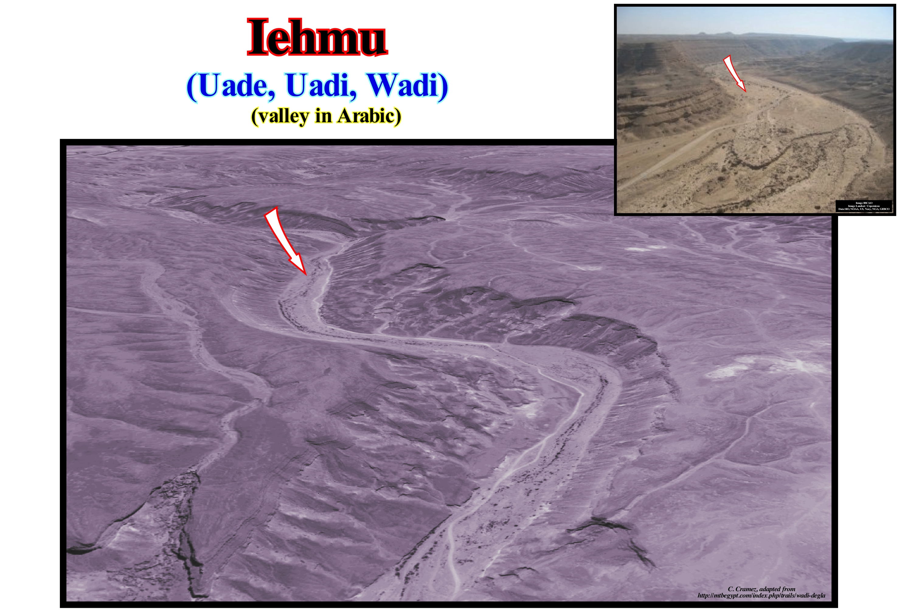
These photographs illustrate the Degla valley, which is located in the northern part of the Eastern Desert of Egypt, not far from the city of Cairo. This particular valley, since the current of the Degla is only present during the great rains, it has a length of about 30 kilometers and is oriented, more or less, perpendicularly to the valley of the Nile river, where it ends, southward of Maadi city. Every stream is a water-course, which channels the floods. Conventionally, the median line of a current, where the two sides of the valley intersect is the thalweg. Although the current did not exist when these photographs were taken, it is, relatively, easy to guess the position of the thalweg. The water-courses, when permanent, have different names according to size and behaviour. A river is an important stream, whereas a brook is a current smaller, but larger than a rill. The non-permanent currents are the torrents (rapid and impetuous water-streams that comes from the great rains or the sudden melting of the snows) that disappear during the dry seasons. In desertic areas, such as in the area depicted in these photographs, the torrents dig subhorizontal bottoms and steep valleys forming what the Spaniards call "arroyos" and the Arabs "widian" (plural wadi). Widian deposition is very rapid due to the sudden loss of torrent velocity and the infiltration of water into the porous substrate. On this subject, we remember having crossed, hardly, a wadi by, in the region of Kairouan (Tunisia), to go to the hotel to sleep. Next day, the crossing of the wadi was much easier, since during the night, a flood completely filled it with sediments. Wadi deposits are almost always made up of sand and poorly calibrated blocks, which are later reworked by the wind.
Walther's Law............................................................................................................................................................................................................Loi de Walther
Lei de Walther / Ley de Walther / Walther-Gesetz / 瓦尔特的法律 / Закон Вальтера / Legge di Walther /
In continuity of sedimentation, a lateral succession of depositional systems is found, also, vertically. If, laterally, in the direction of the sea, there is an a, b, c succession, vertically, from bottom to top, we will find c, b, a.
See: « Stratification (sediments) »
&
« Geological Principle »
&
« Systems Tract »
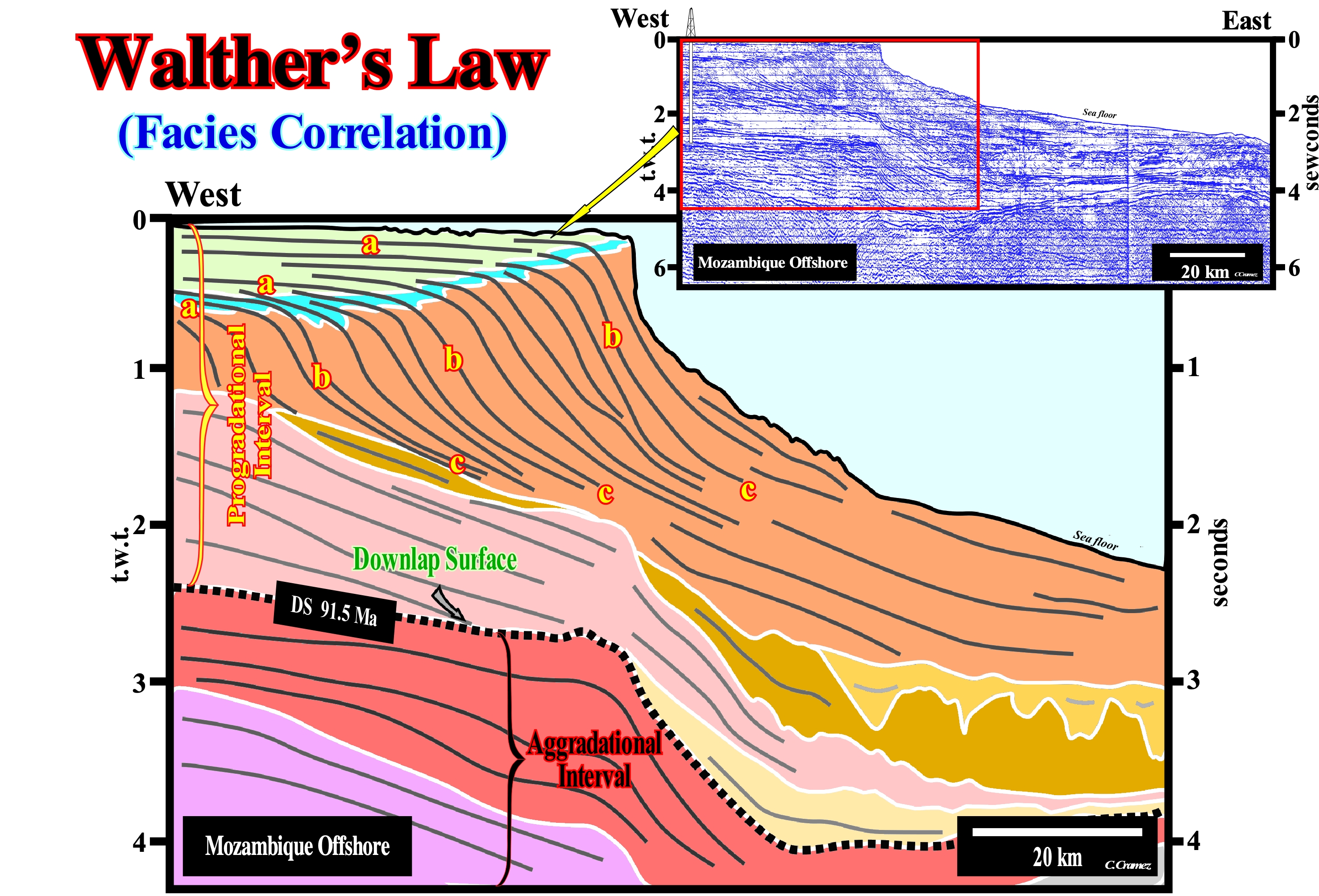
It was the German geoscientist Walther, who studied the relationships between facies* (lithology and associated fauna) and sedimentary environments. He acknowledged depositional environments change, laterally, over time, and as a result, the facies of adjacent depositional environments succeed one another as a vertical sequence. He found the vertical succession of the facies is the same as the lateral succession. On this tentative interpretation of a Canvas auto-trace of a regional seismic line from Mozambique offshore, the lateral succession of facies abc (a = silts of deltaic plain with limestone constructions at the downstream ; b = shales of continental slope and c= shales and sands of abyssal plain) is found, also, vertically (cba from bottom to top). This law (Walther's law) is, just, valid in continuity of sedimentation, i.e., in stratigraphic sections without unconformities (erosional surfaces induced by significant relative sea level falls) and, particularly, without tectonically enhanced unconformities (angular unconformities). This law can only be applied in sections that are not subdivided by diachronic surfaces, such as transgressive surfaces or facies lines. However, although sequence-paracycles sets and sequence-cycles are subdivided by diachronic surfaces, Walther's law is used to interpret the depositional context of the associated sedimentary intervals. The diachronic character of the surfaces (unconformities, facies lines and ravinment surfaces), for practical reasons, is ignored and the sedimentary packages (sedimentary systems tracts, sequence-paracycles and stratigraphic-cycles) are considered, more or less, as coeval. The sediments overlying and underlying such a diachronic surfaces that limit each of these stratigraphic units are either younger or, on the contrary, older than the unit in question. The sediments, which form a sedimentary unit, either a sequence-paracycle or a sequence-cycle are assumed to be synchronous. On seismic lines, given the seismic resolution, the error is minimal. On this tentative geological interpretation it is important to take into account the pitfall induced by the abrupt and continuous variation of the water-depth, since the seismic waves move faster in the sedimentary intervals than in the water. Thus, it is possible that the downlap surface DS. 91.5 Ma, in a depth-version, be subhorizontal or even slightly dipping Westward. A lot of geoscientists think that on a divergent margin, the breakup unconformity, which emphasizes the beginning of the margin, dips seaward, which is not the case. On the tentative geological interpretation of the seismic lines, in addition to the law of J. Walther, other geological laws must always be used: (a) Goguel's Law, which says during deformation, the volume of sediments remains, more or less, constant (this law is approximate since it takes into account the volume reduction induced by the decrease in porosity in depth and by the dissolution phenomena which can in certain cases reach about 30% of the total volume) ; (b) Steno's law that said the sedimentary layers are deposited in relation to time, i.e., the oldest in the lower part and the most recent ones in the upper part (this law is fundamental to the interpretation of Earth's history, since in any location, it indicates the relative age of the layers and fossils that they contain ; (c) Original Horizontality Law, which states that the sedimentary layers are deposited horizontally ; (d) Original Continuity Lateral Law, according to which the sedimentary layers settle in lateral continuity thin down to zero or end by downlaps or onlaps against the edges of the original depositional sectors ; (e) Intrusion Law, which says that the relative age between two igneous rocks, or between an igneous rock and a sedimentary rock, can be deduced by the geometrical relations between them: "An intrusive igneous rock is younger than the rock it penetrates "; (f) Ochkam's Law, which says that plurality should not be invoked without necessity ("Pluritas non est ponenda sine necessitate"), etc., etc.
(*) It was the Swiss geoscientist Amanz Gressly, who in 1838 used the term facies to express: (i) The lithological aspect of the stratigraphic unit, which is linked to a paleontological complex and (ii) The set of fossils that invariably excluded other facies. However, in 1898, J. Walther considered the law or the correlation of facies saying: "The various deposits of the same facies (" faciesbezirk ") as well as a set of rocks of different facies are, spatially, formed side by side, though in a cross-section are seen on top of each other". Haug (1907) standardized the meaning of facies as the sum of the lithological and paleontological characteristics of a particular deposit in a given place. Selley (1970) emphasized that all proposed facies definitions are, merely, descriptive and therefore expressions such as fluvial facies or turbiditic facies are not relevant. The concept of facies tracts (Walther's "faciesbezirk" Walther, an idea partially taken from Gressly, was adopted for a whole rocky body, and not only for vertical succession, by Busch (1971) and called "genetic increment of strata" (IGS). In 1977, Brown and Fischer used the same concept (faciesbezirk "Walther) in facies analysis which was renamed as " systems tract ".
Walther's Principle.........................................................................................................................................................Principe de Walther
Princípio de Walther / Principio de Walther / Prinzip der Walther / 瓦尔特原则 / Закон Уолтера / Principio di Walther /
The facies (lithology + fauna) that follow each other, vertically, in conforming strata, succeed laterally in adjacent environments. In continuity of sedimentation, if a geoscientist recognizes, laterally, a sandy facies of coastal plain, a shaly facies of continental slope and, finally, a clay facies of abyssal plain, he will recognize, vertically, and from bottom to top, a clay facies of the abyssal plain, a shaly facies of continentall slope and, finally, a sandy facies of coastal plain.
See: « Stratification (sediments) »
&
« Facies »
&
« Geological Principle »
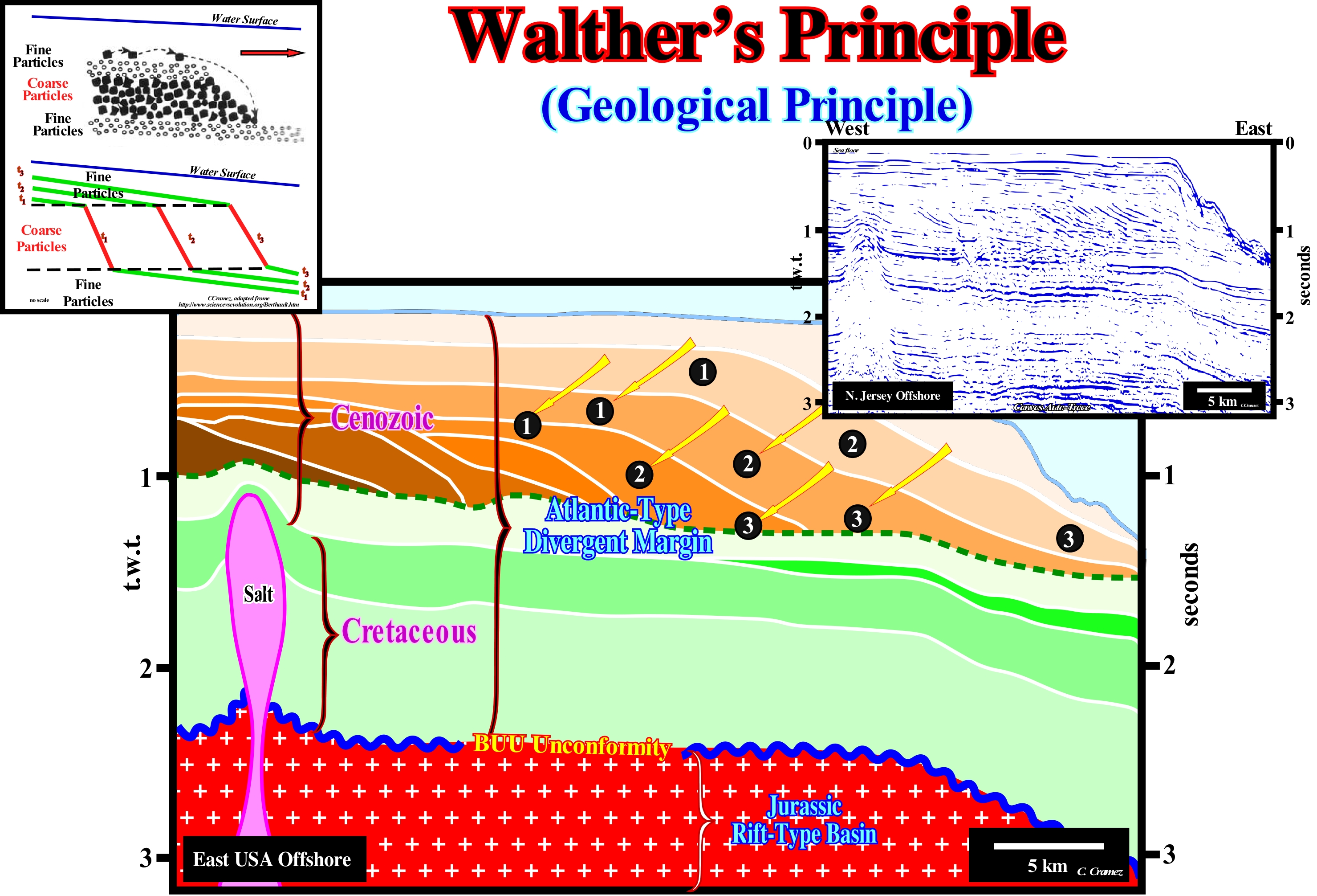
The principle of facies correlation or Walther's law says contiguous facies in sedimentation environments may appear superimposed on the stratigraphic record, which is of great importance for sedimentological interpretation and for paleogeographic reconstructions, since it characterizes the displacement capacity of sedimentary environments function of terrigeneous influx and tectonic. The sedimentary basins, under conditions of tectonic stability, tend to silting what determines the overlapping of the less deep over deep facies. On this tentative interpretation of a Canvas an auto-trace of a New Jersey offshore seismic line (detail), in areas where sedimentation is continuous, one recognizes a sandy facies of the coastal plain (1), then, laterally, a shaly facies of the continental slope (2) and, finally, a clayey facies of abyssal plain (3). Vertically, and from bottom to top, a clayey facies of the abyssal plain (3), a shaly facies of the continental slope (2) and, finally, at the top, a sandy facies of the coastal plain (1) are, also, recognized. On th tentative geological interpretation, the downlap surface (emphasized by the dashed line coloured in green) is, practically, subhorizontal, especially, considering the lowering of the seismic reflectors below the current continental slope, i.e., taking into account account the pitfall induced by the abrupt variation of the water-depth. Such a geometry means the influence of tectonics on the creation of available space for sediments (particularly shelfal accommodation) was, practically, null. This means means the post-Pangea regressive phase of the continental encroachment cycle was, fundamentally, controlled by eustacy, i.e., by the changes of absolute or eustatic sea level (supposed global and referenced to the Earth's centre). Besides this principle, in Geology there are many other principles or hypotheses, among which we can mention: (i) Composition Principle - a rock represented by fragments in another rock is older than the rock that contains them ; (ii) Carbonated Bucket Principle - the growth architecture of a rimmed carbonate platform resembles the geometry of a bucket or inverted cone trunk ; (iii) Original Horizontality Principle - the sedimentary layers deposit horizontally (not totally true) ; (iv) Intersection Principle - the most recent veins* (distinct sheet-like body of crystallized minerals within a rock) move the oldest veins ; (v) Intrusion Principle - an igneous intrusive rock is younger than the rock it penetrates ; (vi) Ochkam's Principle - plurality should not be invoked without necessity: "Pluritas non est ponenda sine necessitate" ; (vii) Goguel's principle - during deformation, the volume of the sediment remains, more or less, constant ; (viii) Original Lateral Continuity Principle - the sedimentary layers settle in lateral continuity ; (ix) Fossil Succession Principle - the distribution of fossils in rocks is not unpredictable, it follows a definite vertical sequence ; (x) Dextrological Principle - if a reference system rotates clockwise the deflection (Coriolis effect) is to the left of the object, in the direction of motion ; (xi) Uniformity Principle - geological changes are due mainly to the same ongoing processes and changes that are currently observed ; (xii) Superposition Principle - in a slightly deformed sedimentary serie, the oldest layers are at the base and the most recent layers above ; (xiii) Catastrophism Principle - changes that occurred on Earth were due to the occurrence of major natural disasters ; (xiii) Continental Drift Principle - the continental masses have a small density and, for this reason, floated on the oceanic dense masses, moving and changing the planet's surface ; (xiv) Plate Tectonics Principle - the lithospheric plates, which contain the continents, move in time and space ; (xiv) Neocatastrophism Principle - admits uniformitarianism as the main guide, but does not exclude occasional catastrophic phenomena contributing to eventual changes in the earth's surface (Neocatastrophism associates catastrophic with Uniformitarianism ideas to explain certain phenomena such as the extinction of dinosaurs, etc.).
(*) A vein is a blade of rock, thick from a few centimeters to a few meters, intersecting the main rock (what distinguishes it from a sill, laccolite ) and corresponding most often to the filling of a fracture (fault, diaclase).
Washover...........................................................................................................................................................................................Dépôt de débordement
Depósito de galgamento / Depósito de desbordamiento / Washover Anzahlung / Washover存款 / Намывное отложение / Doratore, Deposito di onde che oltrepassano il ripiano littorale /
Sediments deposited by the action of overbanking, which means the transportation agent forces the sedimentary particles to jump over obstacles. The more frequent obstacle is, in general, a barrier bar, which limits the outer side (oceanward) of a lagoon.
See: « Delta »
&
« Storm Delta »
&
« Major Storm Wave Base »
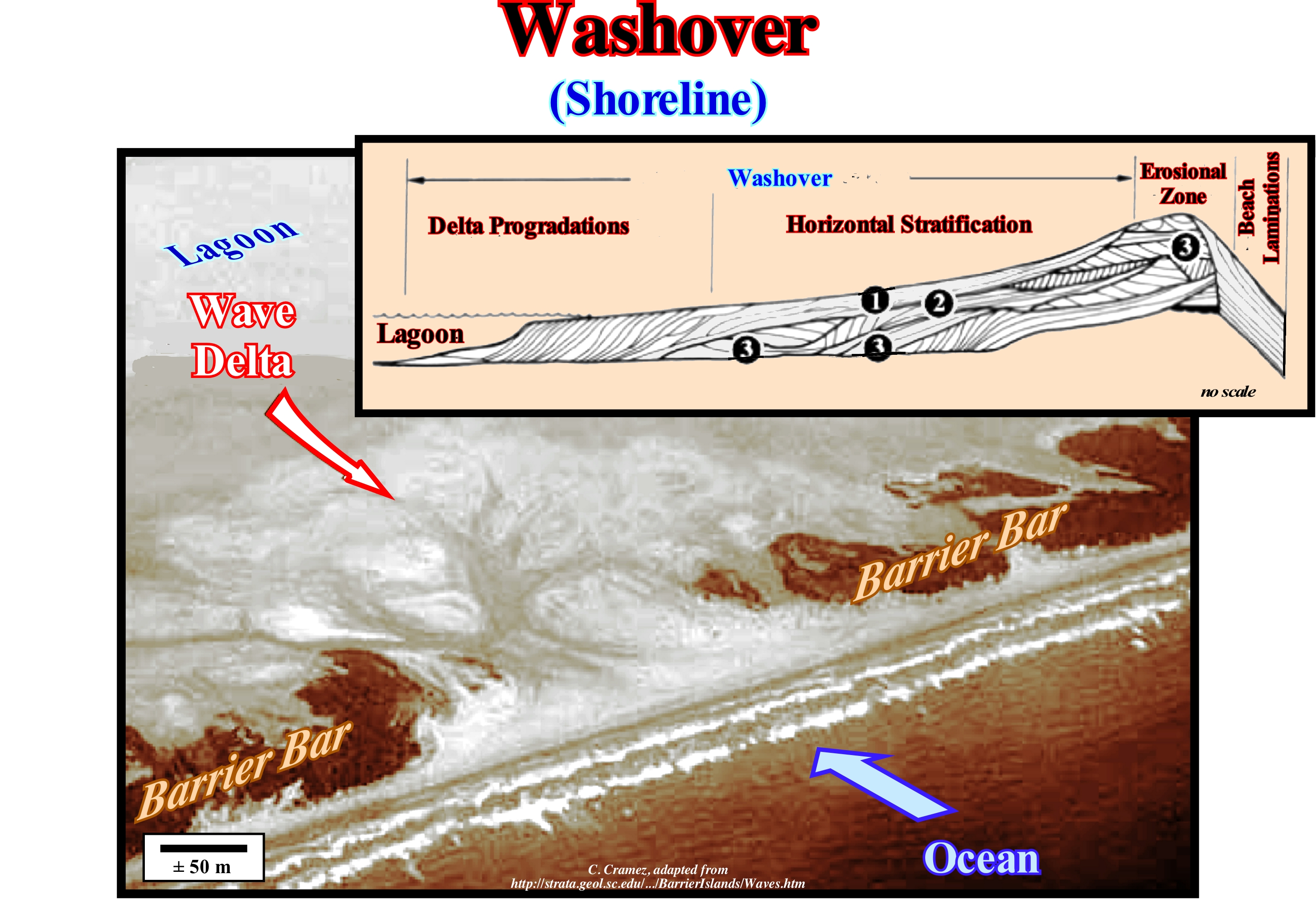
The term washover, which is synonymous with overflowing or overbanking, is used here to express the movement of the sea-waves over the barrier-bars. The barrier-bars, also called barrier coast, are geological bodies occurring along the coast, made up of heterogeneous material, usually, sands and pebbles These sedimentary particles, which come from the wear of the coast or are brought by the water-courses flowing into the coast, are deposited when the speed of marine currents decreases due to low depth. In this photograph, a large fan of sand (storm delta) was built on the continent side of a barrier-bar, which separates the ocean from a lagoon of significant size. Geoscientists think this clastic sedimentary construction was induced by the formation of sea-waves. In this particular case, it can be said during one or several storms the sea-waves passed over the coastline (partially eroding it) and deposited the eroded sediments and others (transported from farther) on the front of the lagoon* (area with a small water-depth) in fan-shaped accumulations of sand (similar to small river deltas), which many geoscientists call storm deltas or wave deltas. The thickness of these deposits can range from a few centimeters to several meters. Storms with their great energy and the very strong winds (usually associated), are able to displace large amounts of water. It is necessary to take into account that as gravity is the main law, water moves, rapidly, under the action of a force, but returns to its normal state as soon as the force is withdrawn. The movement of water is one of the great forces of erosion. Large amounts of water can destroy sand bodies very easily, including the coastal barrier-bars. If a storm is, sufficiently, strong, the longshore** of a barrier-bar can be, significantly, eroded in such a way that dunes and coastal forests are forced to retreat or are, totally, or, partially, destroyed. Such erosion exposes, also, the inner part of the barrier-bars to erosion. The washover follow the rules of sedimentology. Above the barrier-bars, the washover exhibit a parallel internal configuration, but as the water-depth of the lagoon's edge increases, they exhibit internal sigmoidal configurations, which characterize the storm delta. As illustrated in the geological sketch at the top right of this figure, the storm deltas have, roughly, the same internal geometry as any other delta, with a, more or less, sub-horizontal stratification in the proximal part, where the slopping beds are, poorly, developed and a seaward bedding in the distal portion (near the lagoon). The seaward dipping layers (prodelta) are preponderant, while the upper beds (topsets) are almost nonexistent. In addition, the absence of the lower beds (bottomsets) is, almost always, a rule of this type of deltas. Within the different types of delta, function of the dynamics of the delta and the form of the emergent plain, besides the storm delta, we can mention: (i) Abandoned deltas or subdeltas ; (ii) Alluvial deltas ; (iii) Arctic Deltas ; (iv) Rounded deltas ; (v) Atrophied Deltas ; (vi) Complex or polymorphic deltas ; (vii) Cuspate deltas ; (viii) Finger Deltas ; (ix) Flood deltas; (x) Closed Deltas ; (xi) Gilbert type deltas ; (xii) Lava deltas ; (xiii) Lobate deltas ; (xiv) Tidal deltas; (xv) Submarine deltas ; (xvi) Wave deltas; (xvii) Ebb deltas, etc.
(*) Natural water reservoir which may have different dimensions and form from the mouth of a stream or river or, failing that, during periods of flooding due to overflowing by one of them and subsequent water stagnation. Generally, lagoons are formed of salt water, although there are fresh water lagoons. It is worth mentioning that fresh water is one that has minimal amounts of mineral salts dissolved in the interior, while salt water abounds in such components. The first is found in rivers, streams and brooks. The second is found in the sea and most lagoons. The differences between lakes and lagoons have nothing to do with size, although there are certain characteristics that must have an aquifer extension to be considered one thing or another. Although both water reservoirs can be fed by water-courses, a lake has fresh water, since it is an inlet and an outlet and water flows through the lake. In the case of lagoons, they are also fed by water-courses, but do not have an outlet, so the only way they can be emptied is through evaporation. Water is salty because it contains a large amount of minerals, which are stored in the soil when the water evaporates. This is why lagoons are mirrors of closed water, because they have stagnant water. Anyway, there are some freshwater lagoons, related to the type of soil in which there are not many minerals that, when the water evaporates, are absorbed by the soil. (http://definicion.de/laguna/) Posted: 2009. Updated: 2013).
(**) Part of the beach that is always submerged and that extends out from the limit of the low tides to an undefined space at the bottom of which are localized the longshore runnels and ridges.
Water-course (Stream)....................................................................................................................................................................................Cours d'eau
Curso de água / Curso de agua / Strom / 流 / Поток / Corso d'acqua /
General term for any water-body, large or small, that channels currents and floods, under the action of gravity. Water-body which flows in a confined manner, i.e., in a bed (channel) defined by lateral banks. Depending on its location and certain characteristics a water-course may be a creek, runnel, rivulet, bayou, beck, etc. Synonym with Stream.
See: « River »
&
« Sediment Supply »
&
« Turbidity Current »
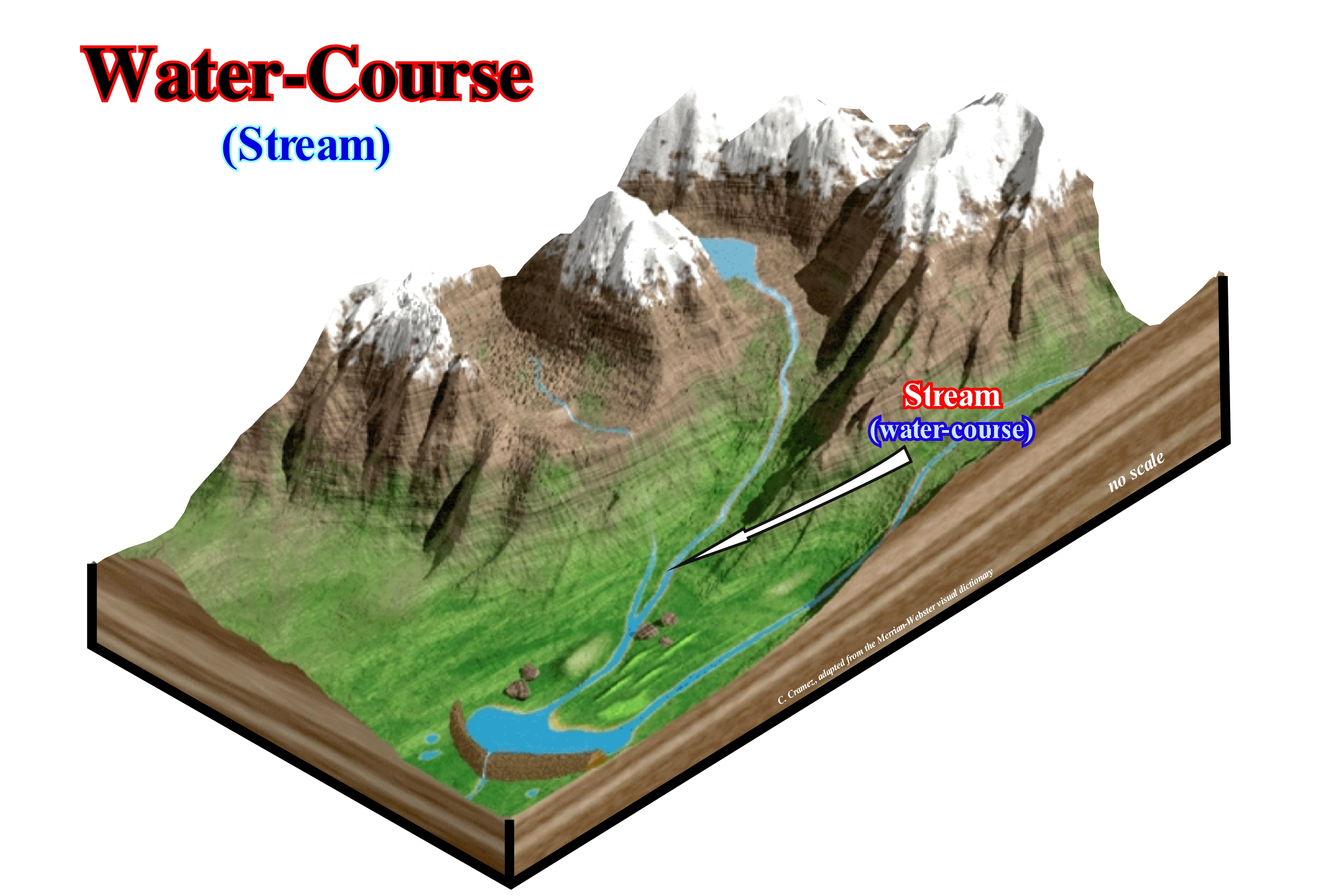
In a water-course or stream, main elements are: (i) The Spring ; (ii) The Source ; (iii) The Headwaters ; (iv) The Confluence ; (v) The Run ; (vi) The Bar ; (vii) The Riffle ; (viii) The Channel ; (ix) Rapids ; (x) The Floodplain ; (xi) The Thalweg ; (xii) The Wetted Perimeter ; (xiii) The Knickpoint ; (xiv) The Waterfall or Cascade ; (xv) The Mouth ; (xvi) Drainage basin ; (xvii) The Gaging Station. The Spring* is the point at which the stream begins or emerges from an underground path through poorly consolidated sediments or caves (the latter case being particularly frequent in calcareous regions where karsification is abundant and where a current may have an underground course, more or less, long before it emerges. The spring is the point where groundwater flows out of the ground, and where the surface of the aquifer meets the ground surface. The Source is the spring from which the current originates or any other point that originated it. The source is simply the point at which it starts, i.e. the original point from which the river or stream flows. A river's source is sometimes a spring. The Headwaters is the part of the current near the source (term used, especially when the current has several sources). The Confluence is the point where two currents come together (when two distributives have approximately the same importance, the confluence may be called a fork. The Run is the rectilinear segment where the stream flows without agitation (swimming-friendly area), the current it is deeper and flows more slowly. The Bar is a shoal that develops in a stream as sediment is deposited as the current slows or is impeded by wave action at the confluence. The Riffle is the segment or area where the flow is shallower and more turbulent. The Riffle is segment or area where the water depth is lower and more turbulent. The Channel is the depression created by the erosion that allows the flow of the current. The Floodplain is the region adjacent to the stream which is subject to being flooded when the stream overflows. The Thalweg is the longitudinal section of the river or the line connecting the lowest point of the channel from the source to the mouth. The Wetted Perimeter is the line on which current surface meets the channel walls or the perimeter of the cross sectional area that is "wet". The Knickpoint is the point on a stream's profile where a sudden change in stream gradient occurs. The Waterfall or Cascade is the fall of water where the stream goes over a a knickpoint. The Mouth is the point at which the current is discharged and which, generally, corresponds to the shoreline, possibly via an estuary or delta. The Drainage basin is the area of land where water flows into a stream. The Gaging Station is the demarcation point along the current path which is used as the reference mark and where the control apparatus are installed. Function of size and behaviour, a water-courser can be called river, brook (a small stream), streamlet (rivulet), rill, beck, bourn, fleet, etc.
(*) A spring may be the source of a river but a source is not necessarily a spring.
Water Table (Subterranean stream).......................................................................................Plan d'eau (Niveau de la nappe phréatique)
Plano de água / Plano de agua, Tabla de agua corriente subterránea / Grundwasserspiegel, Körper von Wasser (Grundwasser) / 水体(地下水位) / Водяная поверхность (уровень грунтовых вод) / Corpo di acqua (livello delle acque sotterranee) /
Vast deposit of underground water fed by rain-water filtered through the rocks it crosses, in which the pressure of the water level equals atmospheric pressure, in other words, the water table is a collection of points where the absolute pressure* equals the atmospheric pressure and the relative pressure, i.e., the pressure due to water only (gage pressure) equals zero. Groundwater feeds springs and can be exploited by wells.
See: « Resurgence (stream) »
&
« Cave »
&
« Stream »
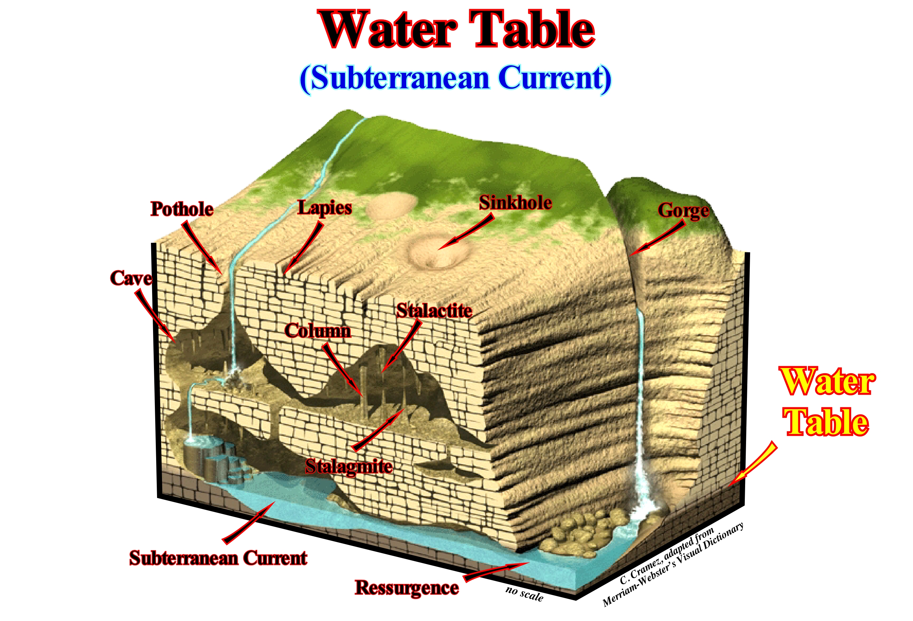
An subterranean water is a water that lies beneath the Earth's surface. However, not all subsurface water is groundwater. Knowledge of different types of subsurface water and geology often explains why certain water-table range from tens of meters, tens of centimeters, and others almost nothing. The upper surface of the subterranean water is the water plane. Underneath it, the porosity and fractures of the rocks are completely filled with water, which means that they are saturated with water. The saturated horizons of water, known as, saturated zone or water table, exist where there is underground water. Only water found in the saturated zone is considered subterranean water. The water plane is the level at which the subterranean water pressure equals atmospheric pressure, which, generally, coincides with the water-table, but which may also be several meters above. Water-table and water plane, sometimes, they mean the same, but not always. While the upper most level (the top) of the saturated zone, in an unconfined aquifer, is the water table. The level of water seen in a well is, commonly, referred as water plane. The depth of dynamic water plane lies, always, below the water-table. A confined aquifer is an aquifer below the land surface that is saturated with water. A water-table or unconfined aquifer is an aquifer whose upper water surface (water table) is at atmospheric pressure, and thus is able to rise and fall. The water infiltrates through the porous spaces of the soil and begins to reach the aeration zone, that is, the area where the terrain is not saturated with water. At a greater depth, the water fills more pores until the saturation zone is reached. As said before and as illustrated in this sketch, it is the, more or less, horizontal plane passing through the top of this zone which is called the water plane. An amount of sustainable water (which can be maintained) within a sedimentary unit or interval, located below the water plane, i.e. in the water table, is called an aquifer. The ability of an aquifer to store groundwater depends primarily on the porosity and permeability of the rocks where it is formed. A fossil water is groundwater that has remained in an aquifer for a significant geological time. Fossil waters are very common in deserts. Fossil waters are deep non-renewable groundwater (by rain-water). When a fossil water is subjected to any type of mining (extraction of a nonrenewable resource) the water plan undergoes very important permanent changes and may even disappear.
(*) Absolute pressure is the pressure measured with respect to perfect vacuum or zero pressure, so it is equal to gauge pressure plus atmospheric pressure. Gauge pressure is zero-referenced against ambient air pressure, so it is equal to absolute pressure minus atmospheric pressure. Differential pressure is the difference in pressure between two points.
Waterpocket (Pothole)......................................................................................................................................................................Mares (Karst littoral)
Marmitas litorais (ouriçangas litorais, carso litoral) / Marmita litorales, Karst litoral / Opperkessel / 坑洼 / Водяной мешок / Mares (carsico costiero) /
Form of coastal karst dissolution, which develops on the bottom of solution benches or between littoral clints.
See: « Coastal Karst »
&
« Solution Bench »
&
« Littoral Clint »

The forms of dissolution that develop in the bottom of solution benches (small dissolution platforms with flat bottom or small with littoral clints and with and slits surrounded by a low edge, more or less, 10 to 30 cm, or between the littoral clints) or in the upper mesolittoral zone and supralittoral zone with pinnacle forms and sharp edges, leaving, among them, small dissolution waterpockets, sometimes with a funnel shape). The waterpockets have a cylindrical shape with a flat bottom, usually, with a deposit of sand, pebbles and shells, and smooth walls, covered with living organisms characteristic of the infratidal zone. As shown in this figure, the shape, broader at the base than at the top, of these waterpockets, (called "goldfish", in certain Central American islands) suggest whirling mechanical processes. If the waterpockets result from the coalescence of simple forms, sometimes preserved between the coalescing remains (which form rocky walls), the perimeter is circular, elliptical or even lobate. They may or may not have a edge, which may be erosional, bioconstructed or mixed. Its depth varies between about 10 cm and 5 or 6 meters (or more). The deepest are at the top of the strand (coastal space between the higher high-tide and lower low-tide levels that certain geoscientists call the intertidal zone). The dissolution processes are essentially biochemical and each waterpocket represents an ecological niche, i.e., the way of life of each species in its habitat. An ecological niche represents all the activities of the species, including food relations, obtaining shelters and places of reproduction, that is, where and at the expense of whom the species feeds, for whom it serves as food, when, how and where they find shelter and how and where it reproduces. In a classical comparison, habitat is the "address" of the species, and the ecological niche is equivalent to "profession." In African savannahs, the grass, zebras, lions and vultures occupy the same habitat, but have distinct ecological niches. The herb produces organic matter through photosynthesis and serves as food for zebras, which are eaten by lions and the remains are recovered by vultures.
Wave.........................................................................................................................................................................................................................................................................Onde
Onda / Ola / Welle / 波 / Волна / Onda /
Disturbance that spreads through space and time, usually, with energy transfer. A mechanical wave is a wave that propagates or crosses a medium, due to the restoring forces that produces the deformation.
See: « Love's wave »
&
« Tsunami »
&
« Charge (seismic) »

When a hammer hit against a metal or a stone parallelepiped, the atoms begin to vibrate and give rise to a wave. If we hit the end of the parallelepiped we generate a compression wave, if we hit above or below, we generate a shear wave. It is not matter that spreads. The material stay in the affected place, but moves back and forth. The idea that it is just the shock that spreads and not matter is understood well if we consider the example of earthquakes, which are shocks created by failures within the Earth. The earthquakes emit waves, vibrations, that propagate in the Earth at a speed of 20,000 to 30,000 km/h (± 5,500 to 8,300 m/s). It is evident that when a vibration occurs after an earthquake that occurred a quarter of an hour earlier, at 5,000 km from where an observer is, it that does not mean the matter moved from that distance in fifteen minutes. Do not forget that feelings can be misleading. When observing sea-waves along the coastline, and seeing the sea-water running on the beach, we tend to think that sea-waves corresponds to a fluid displacement. The displacement of matter occurs, only, when a wave breaks on the beach because the depth of the sea floor is to small. At that precise moment, the water moves, laterally, toward the beach, but if you look a little further off, you will notice that the ripple is a vibration whose displacement of matter takes the form of local rollers. Perhaps one of the best ways to understand what a wave is is to attend a soccer game, for example between Portugal and Spain. At a certain moment, especially, if Portugal has scored a goal, the spectators make a "hola" , that is, a wave. In a continuous and progressive way, the spectators rise and sit down when the contiguous ones rise and so on. All people are in the same place, that is, matter does not move, but the wave does. The same is depicted in this figure, where the up- down movement of a surface water particle transport the energy without any transport of the matter, since the water particle stay in the same place . It oscillates, repeatedly, at each point propagating the energy from each point to neighbouring points.
Wave Action Level (Wave base).......................................................................................Profondeur d'action des vagues
Nível de acção das vagas / Nivel de acción de olas / Tiefe von Wellenschlag / 波浪作用的深度 / Глубина воздействия волн / Profondità di azione dell’onde /
Depth of erosional wave action. This depth depends on the weather conditions. Three situations can be considered: (i) Fair Weather Wave Base, i.e., about 10 m of depth, which corresponds, more or less, to the position of the depositional coastal break of the depositional surface ; (ii) Average Storm Wave Base, about 30 m deep and (iii) Major Storm Wave Base, which corresponds to about 50 m depth.
See: « Fair Weather Wave Base »
&
« Storm Delta »
&
« Ravinment Surface »
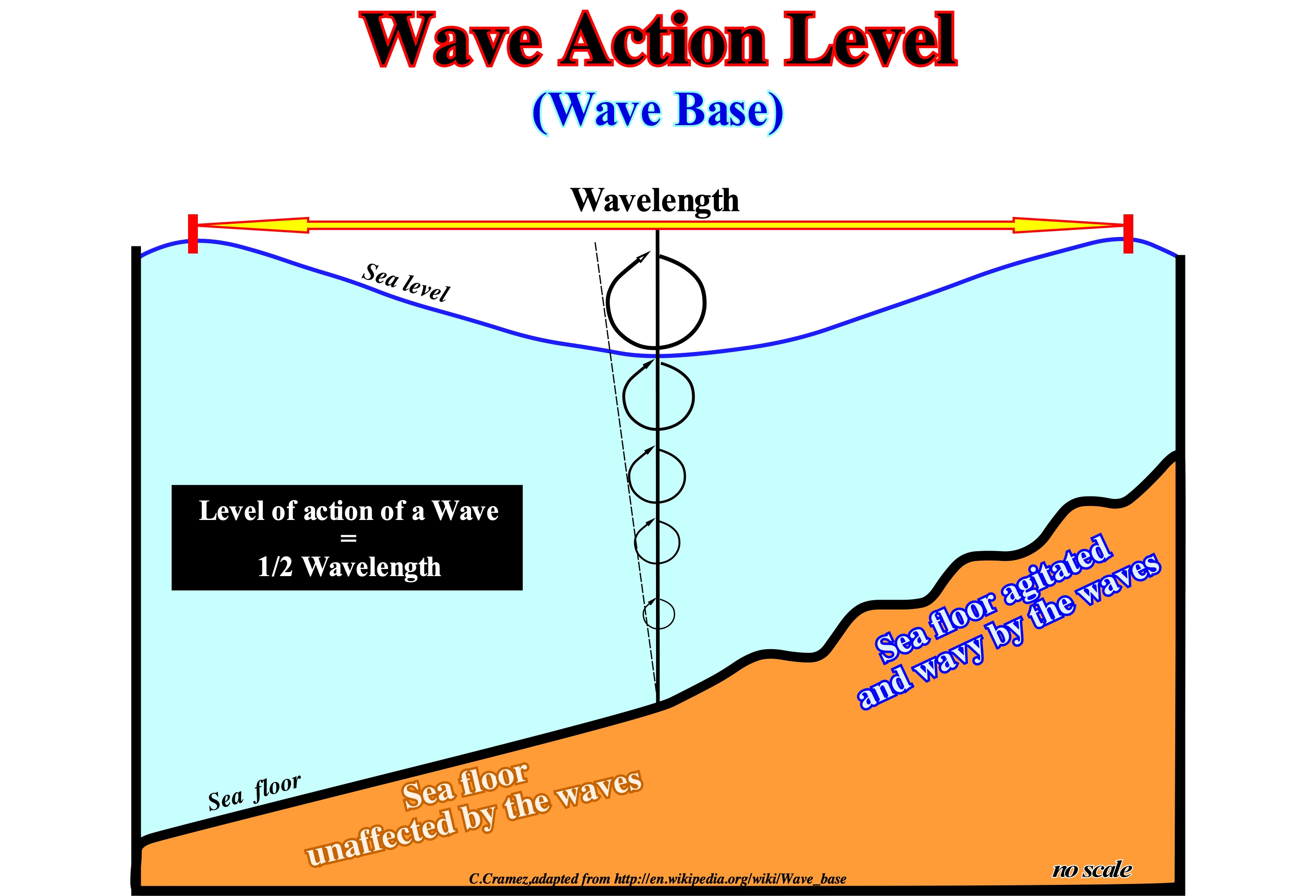
The sea-waves are created by the wind that transfers the energy of the movement towards the water. When the wind speed is small (between 5 and 20 km/h) small waves are formed that do not exceed a few centimeters in height. As the wind speed increases, the wave-height increases. Wave-height increases with: (i) Wind speed ; (ii) The time during which the wind blows and (iii) The distance over which the wind blows. Storms form very large and irregular waves that propagate out of the storm zone, like when a stone is dropped in the calm lake. As the waves move away from the storm zone they become smaller, regular and rounded. The waves travel like a shape, but the water stays in the same place. The small particles of water below or at the water surface move in vertical circular orbits. At a given point, along the path of a wave, all water particles are in the same positions relative to their orbits, regardless of depth. The rays of the orbits, as illustrated in this figure, are, relatively, large near the water surface, but gradually, diminish in depth until they become null. The depth at which the rays of the orbits are null determines the limit of the wave action level. The reason for this decrease is the greater the distance of a particle of water to the surface, the further away it is from the force of the wind (plus the viscosity forces resist the movement of water). The movement of the waveform towards the coast is given by the trace of the orbits, the troughs following the base of the orbits and the crest following the top. The speed of a wave is a phase velocity. What moves is not the water, but the troughs and crests, i.e., the phase of the water surface. As in the sea-waves, the "wave" made by spectators of a sport event, such as a soccer game shows that it is the visual effect of a wave that runs through the stadium. The spectators do not move. They stand up, in successive rows perpendicular to the soccer field, rising the arms and then sit down. The wavelength corresponds to the maximum distance that a particle suffers from the equilibrium position. To determine the wavelength it is sufficient to measure the distance from the equilibrium position to a crest (or to a trough). The wave frequency corresponds to the number of crests passing by a certain point in 1 second or to the number of full vibrations that a particle makes in 1 second. The frequency unity is the Hertz. A frequency of 10 Hertz (Hz) means 10 full vibrations per second. The wave propagation speed is the speed with which the wave propagates in a given medium. It depends on the distance travelled by the wave and the time interval spent to traverse this distance. The erosive action of the waves depends on the state of the sea: (i) When the sea is agitated, it can reach about 50 m or more in water-depth, especially during heavy storms ; (ii) When the sea is moderately agitated, the erosive action of the waves can reach a depth of about 30 meters, which means that the distance between two successive waves (distance between two crests or two consecutive troughs) is about of 60 meters, that is, half the wave-length ; (iii) When the sea is calm, it can reach a depth of about 10 meters, roughly corresponding to the position of the depositional coastal break of the depositional surface. About 20% of the emerged land, in contact with the sea, are formed by sandy beaches. Of these, 70% are in the predominant erosional process (retrogradation), 20% in the construction process (progradation) and the remaining 10% are in relative equilibrium (https://pt.wikipedia.org/ wiki / Eros% C3% A3o_marinha). The most probable reason for the predominance of erosion and retrogradation of modern coastlines is, for most geoscientists, the consequence of eustatic or absolute sea level rise since the end of the last ice age. As shown in this figure, the wave action level can be easily determined from the wavelength. It corresponds to half the wavelength. Thus, when the distance between two crests is, ± 40 meters, the depth of wave action level is about 20 meters, which means that if the depth of the sea floor is more than 20 meters, it is not affected by the action of waves.
Wave Base........................................................................................................................................................................................................................................Kymatopausa
Cimatopause / Cimatopausa, Base de ola / Wellenbase / 波基地 / Волновая база / Base dell'onda /
Depth beyond which the oscillatory motion of sea waves is not felt.
See: « Swell »
Wave-Cut Platform (Abrasion platform)...............................................................Plate-forme d'abrasion marine
Plate-forme d'abrasion marine / Plataforma de abrasión / Abrasionplatte / 海蚀台地 / Абразионная платформа / Piattaforma di abrasione /
Slightly sloping rocky surface that extends seaward of the cliff bottom, between the highest and lowest tide levels. It is an abrasion surface that is shaped by the wave action and, as such, tends to be smooth, with slight undulations or with steps corresponding to the level of the high tide or to the sea level reached during storms.
See: « Rimmed Reef Platform »
&
« Drowned Shelf (carbonate platform) »
&
« Shoal-Rimmed Platform »
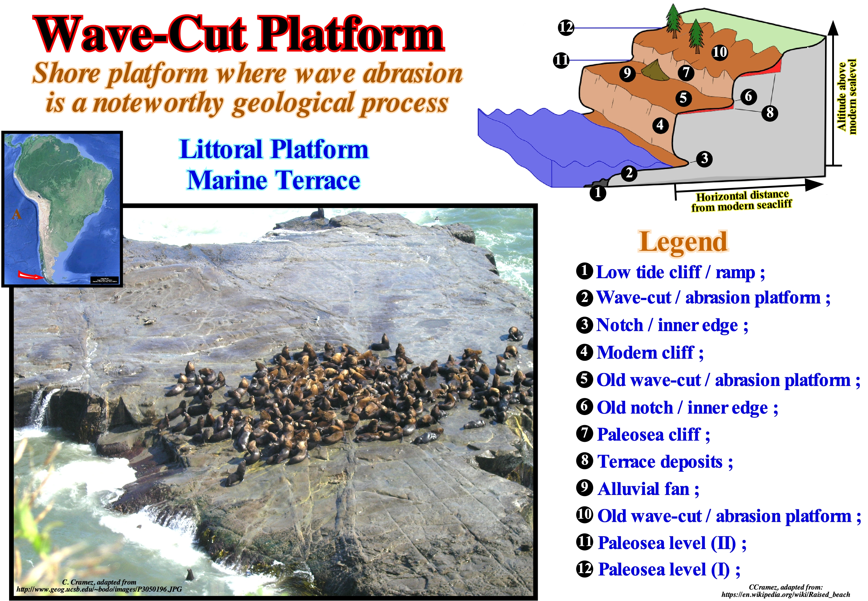
Wave-cut platforms are coastal platforms where the abrasion of wave action is the predominant geological process. When a wave-cut platform is under development, it is exposed, only, during low-tide, as illustrated on this figure, but there is always the possibility that such a platform is hidden under a cover of beach pebbles (which are important abrasion agents). If the shelf is, permanently, exposed, above the high-tide line, it corresponds, probably, to a raised beach platform, which is not considered a product of abrasion. It is the result of a mechanical scraping of a rocky surface by friction between the rocks and moving particles during their transport by wind, glaciers, sea waves, gravity, running water or erosion. After friction, the moving particles dislodge the less consolidated and weaker parts of the rocks, which can also be dissolved in the water. The intensity of the abrasion depends on the hardness, concentration, speed and mass of the moving particles. Erosion is the destruction of soil and rocks and their transportation, usually, made by rainwater, wind or by the action of ice. Ice acts by expanding the material in which the infiltrated water freeze*. Erosion destroys the structures that make-up the soil, releasing sand, clay, oxides, humus, etc. The sedimentary particles and rock debris are transported to the lower parts of the ground and, generally, silting** the water-courses. Abrasion can be considered as one of the mechanical processes of erosion. In forest-covered soils, erosion is quite insignificant and almost non-existent. Erosion is a natural process that is always present and important in the formation of landforms. Since man destroys forests, to use the land in agriculture, erosion becomes very severe in the exposed soil and can lead to desertification (transformation of an area into a desert). When the sea coast is rocky, high and steep, i.e., when cliffs or escarpments emphasize the coastline, erosion induces the retreat of the coast. Such a retreat happens, more or less, as follows: (A) Waves scrape the base of escarpment, which becomes unstable due to the loss of its basal support ; (B) Such an instability causes fragmentation of the cliff and falling blocks ; (C) When the cliff has cracks, the air, located in the cracks, is compressed when the waves shock and decompressed when the waves recede ; (D) The fissures of the rocks are enlarged and the rocks, progressively, fractured ; (E) This damage causes a concave excavation at the foot of the cliffs, that geoscientists call undercut, groove or notch, which, without support, crumble (break or fall apart into fragments) ; (F) In this way, the cliff recedes, developing an abrasion platform (strip of bedrock between the near-offshore and the cliff), which is discovered at low-tide. In the geological schema illustrated on this figure we can distinguish: (i) Low tide cliff/ramp ; (ii) Wave-cut/abrasion platform ; (iii) Notch/inner edge ; (iv) Modern cliff ; (v) Old wave-cut/abrasion platform ; (vi) Old notch/inner edge ; (vii) Paleosea cliff ; (viii) Terrace deposits ; (ix) Alluvial fan ; (x) Old wave-cut/abrasion platform ; (xi) Paleosea level II ; (xii) Paleosea level I. In addition, three abrasion platforms (2), (5) and (10), induced by absolute (eustatic) sea level, can be recognized. Eustasy (absolute sea level changes) is the result of the joint action of (1) Tectono-Eustasy, which is controlled by changes in the volume of oceanic basins induced by the breakup and assemblage of the supercontinents ; (2) Glacio-Eustasy, which is controlled by changes in ocean water volume due to the amount of ice (glaciations and deglaciations***) ; (3) Geoidal-Eustasy, which is controlled by the distribution of ocean water caused by variations in the terrestrial gravity field, and (iv) Thermal expansion of the oceans or steric rise of sea level, indeed when the ocean temperature increases, the density of the water decreases and, for a constant mass, the volume of the oceans increases. Taking into account that just glacial changes are both important (> 10 meters) and quite fast (<1 My), recent abrasion platforms were, certainly, created by glacio-eustasy.
(*) Ice is less dense than water because the orientation of hydrogen bonds causes molecules to push farther apart, which lowers the density (increasing volume).
(**) Silting, aggradation (or alluviation) is the accumulation of debris (sedimentary particles), such as silts, sands, pebbles, boulders, etc., in areas with poor slope of riverbeds, particularly, at the end of their courses.
(***) Transition from full glacial conditions to warm interglacial change the continental ice volume. Such a decrease in continental ice volume induce a significant rise of absolute or eustatic sea level. The melting of "sea pack ice" (formed when water temperature on the surface of the ocean drops to or below the freezing point) or the melting of "ice shelves" (thick floating ice platform formed where a glacier or ice sheet enter into the sea) induce a falling of the absolute sea level, since ice is less dense than water. An "ice sheet", also known as continental glacier, is just a continental ice mass greater than 50,000 km 2. An inlandsis is, just, a very large glacier in the form of an ice sheet covering the mainland, which thickness can reach several thousand meters.
Wave Delta (Storm delta)..........................................................................................................................................................Delta de tempête
Delta de tempestade / Delta de tempestad / Sturmdelta / 风暴三角洲 / Дельта, образованная волнами при шторме / Delta di tempesta /
Delta of relatively small dimensions formed in the inner part (upstream) of the lagoons inlets, bars or barrier-bars, due to the accumulation of materials transported by the storm waves. Synonym with Storm Delta.
See: « Delta »
&
« Storm Delta »
&
« Major Storm Wave Base »

This photograph, which corroborates, perfectly, the geological model illustrated in the diagram, shows two small storm deltas, which, as its name suggests, were formed during a storm or during the equinoctial tides. Certain geoscientists call, also, this type of delta, wave delta. In the geological model of a storm delta, one can recognize: (i) The ocean with waves parallel to the shoreline ; (ii) A barrier-bar with the beach and frontal dunes ; (iii) Openings or passages (inlets) on the barrier-bar ; (iv) The intertidal plain (tidal flat), in which the storm deltas are deposited and (v) The lagoon. In the photograph it is well seen that sea-waves propagate, perpendicularly, to the barrier-bar (or barrier island), which marks the outer limit of a lagoon. In these conditions, i.e., when the wave direction (crests line) is, more or less, parallel to the shoreline, it is unlikely that a significant beach drifting current* (foreshore drift) exists in this area. On the inner side of the barrier-bar, where there was, probably, an old inlet (an entrance to the lagoon), there are at least two recent storm deltas formed by overflowing of the waves during a period in which the height of the waves was very great, as during storms, cyclones or tsunamis. It is very likely that the area where dwellings were built (left sector of the photograph) would also correspond to an old storm delta. The evolution and sedimentological characteristics of the overflow deposits associated with the cyclone Ivan (Florida, 2004) can, ,in general be applied to all storm deltas: (i) The first response to an overflow of sea-waves on a barrier-bar is an important erosion of the longshore, beach and dunes ; (ii) The eroded sediments are transported and redistributed, mainly, on the inner side of the barrier-bar ; (iii) At the beach, deposits are limited by a basal erosional surface and seaward slope ; (iv) In the inner part of the barrier bar, the presence of vegetation beneath the overflow deposits suggests little or no erosion before deposition behind the frontal dune ; (v) At the lagoon platform (area near the shoreline), the deposits have a horizontal or subhorizontal stratification ; (vi) As the water-depth increases, the deposits are thicker and characterized by sigmoid progradations towards the deepest part of the lagoon. Galloway, taking into account the dominant forces in the formation process, classified the deltas into three main types: (i) River-dominated deltas (strong terrigeneous influx) ; (ii) Wave-dominated delta and (iii) Tidal dominated deltas (tidal activity and tidal currents). The river-dominated deltas are cut and have many distributaries with marshes, bays or tidal flats in the interdistributary regions. They occur when the river current and sediment transport are strong and other effects, such as rework by waves or tides, is small. These deltas tend to form large delta lobes in the sea, which may have little more than the distributary channel and they have a natural marginal dikes (levees) exposed above sea level. Due to their resemblance to a bird's paws, they are referred, often, in the geological literature, as a "bird's foot deltas", as is the case of the deltas of Mississippi Delta Building. When much of the floodplain between the distributary channels is exposed above sea level, the delta displays a lobate form. Wave-dominated deltas are more regular, exhibiting curved and arched shapes with frequent beach ridges, such as in the deltas of Nile or Niger delta buildings, where the surf of the waves causes a mixture of fresh and salt-water. The flow lose, immediately, its energy depositing all its load along the coast. Tidal-dominated deltas occur in areas with high tides or in areas where tidal currents have a high speeds. Such deltas often resemble an estuarine bay filled with many elongated islands parallel to the main tidal stream and perpendicular to the shoreline, such as in the Brahmaputra and Mahakam delta buildings. The deltas of the Mississippi and Yukon delta buildings are, typically, dominated by the terrigeneous influx carried by the water-courses. The deltas of Senegal and San Francisco delta buildings are dominated, mainly, by sea wave activities, while those of the Fly delta building are dominated by tides and tidal currents.
(*) Longitudinal current form in the beaches, outside the surfing area, reaching the swash currents, as a consequence of the water and sediments the uprush and backwash currents, when the surfing is obliqued to the coast.
Wave-Height................................................................................................................................................................................................Hauteur (D'une vague)
Altura (da vaga, da onda) / Altura / Wellenhöle / 波高 / Высота волны / Altezza del’onde /
Vertical distance between the crest and adjacent trough of a wave (seismic or not).
See: « Crest (wave) »
&
Wavelength »
&
" Wave "
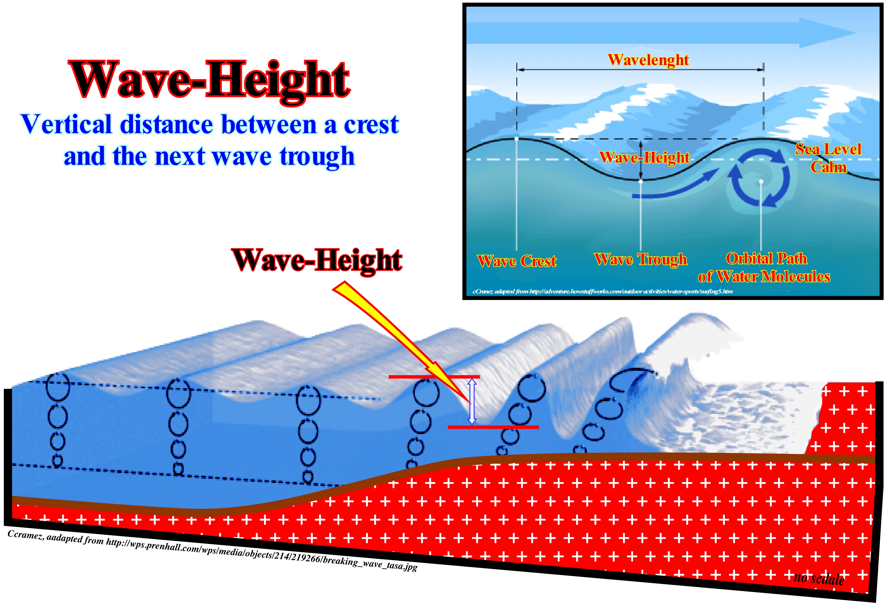
The sea-waves are: (i) Interface waves (there is discontinuity between two fluids of different densities, air-water, allowing the formation of waves) and (ii) Gravity waves (when the interface is not in equilibrium forms a return force to the equilibrium position due to gravity). In the sea everything creates waves. However, most of the sea-waves are created by the wind. When the wind blows on the surface of sea-water, the friction forces oblige the sea to ripple. The wind force, the fetch (extension of the ocean surface over which the wind blows for some time to generate a wave or a wave system) and the duration of the wind determine the wave size. A minimum wind speed of about 1 m/s is required to create the waves. For waves greater than 2-3 m in height, the return or retraction force is the gravity. For waves of smaller height, the return force may be the surface tension (capillary waves). The waves can be subdivided into several components: (i) The crest is the highest point of a wave ; (ii) The trough or valley between two successive crests is the lowest point ; (iii) The wavelength is the horizontal distance between two crests or two consecutive troughs and (iv) The wave-height is the vertical distance between the crest and the next trough. The wave-period is the time that elapses between the passing of two successive crests (or troughs) by the same place. The wave action level depends on the agitation of the sea (calm, agitated or very agitated) and the wavelength. In general, the depth of wave action level is, around, half the wavelength. The higher the wave-height (very rough sea), the deeper the wave action level and the more muddy is the sea (it contains a lot of suspended material from the bottom). In open or high-sea, the waves, generally, have a wavelength between 60-120 m, speeds of 10-15 m/s, periods of 6-9 seconds and heights of 1-2 m. It is the wave action level that during a rise of the relative sea level* produces ravinment surfaces, particularly, in the transgressive interval (Ti) of a sequence-cycle. During lowstand (LPW) and highstand prograding wedge (HPW), when depositional coastal break of the deposition surface corresponds to or is close to the continental edge (basin without shelf), the wave action level can produce instability in the upper part of the continental slope and trigger turbidite currents, which carry the sedimentary particles, stripped from the continental edge, enriching the currents in sedimentary particles, which will be deposited, since the currents lose competence, forming submarine turbidite fans. The deposition is made at the base of the continental slope (submarine slope fans, CST) or on the abyssal plain (submarine basin floor fans, SBFF).
(*) Local sea level referenced, in general, to the sea floor and resulting from the combined action of absolute or eustatic sea level, which is supposed to be global and referenced to the Earth's centre, and tectonics i.e., subsidence or uplift of the sea floor. Uplift of the sea floor occurs when the predominant tectonic regime is compressional: the σ1, i.e., is the main axis of the effective stress ellipsoid (σ1, σ2 and σ3) is horizontal). Subsidence when the predominant tectonic regime is extensional, i.e., σ1 vertical.
Wave-Period.......................................................................................................................................................................................................Période d'onde
Período de onda / Período de onda / Wellenperiode / 波期 / Период волны / Periodo dell'onda /
Time that elapses between the passing of two successive wave crests (or troughs) by the same place.
Ver: « Wavelength »
&
« Crest (wave) »
&
« Wave Height »

As can be deduced from this sketch, the best way to consider a wave is to see how a wave propagates through the water surface of a lake. Waves are created by any kind of disturbance, whether a rock falling on a lake, a boat moving in a river or a storm at sea. A wave has a crest and a trough and the water "seems" to travel from one to the other. The first crest is followed by a second, the second by a third and so on. The crests are separated by troughs (depressions) which creates a succession of crests and troughs. When observing an object floating on sea-waves, whether it be a boat, a seagull, etc., it is easy to see that it rises and falls at regular intervals as the waves pass through it. The wave-period is the time interval between two consecutive crests passing through the same point. At sea, the waves appear to be flat and travel, along the front of the waves, in a straight line, toward the coastline. In a lake, they appear to be circular and travel in all directions, from the point where a stone falls, for instance. Although these mental images are very interesting, they do not correspond to reality. A more realistic picture of how a wave works is that of the waves observed in soccer game when supporters, usually, from the home team, rise up out of their chairs, waving their arms, and then sit down quickly. The first row of supporters rising, abruptly, starts a wave. When they sit down, the second row starts the same movement. When the second row sits, it is the third that begins, and so on. Thus, a wave propagates through the whole stadium without any of the fans leaving their place. In the sea or lake it is the same thing, the water particles move up and down, but always remain in the same place. Near the coastline, the translation waves contrast with the oscillation waves, which we have just described, are formed since the waves break and the water start to travel by translation to the beach (swash currents).
Wave-Range..................................................................................................................................................................................................................................Amplitude (Onde)
Amplitude (onda)/ Amplitud de onda / Wave-Bereich, Wellenhub / 波动范围 / Диапазон волн / Ampiezza dell'onda /
Half the wave-height, measured perpendicular to the axis of the wave (half the vertical distance between the crest and adjacent trough of a wave).
See: « Wave Height »
&
« Crest (wave) »
&
« Wavelength »
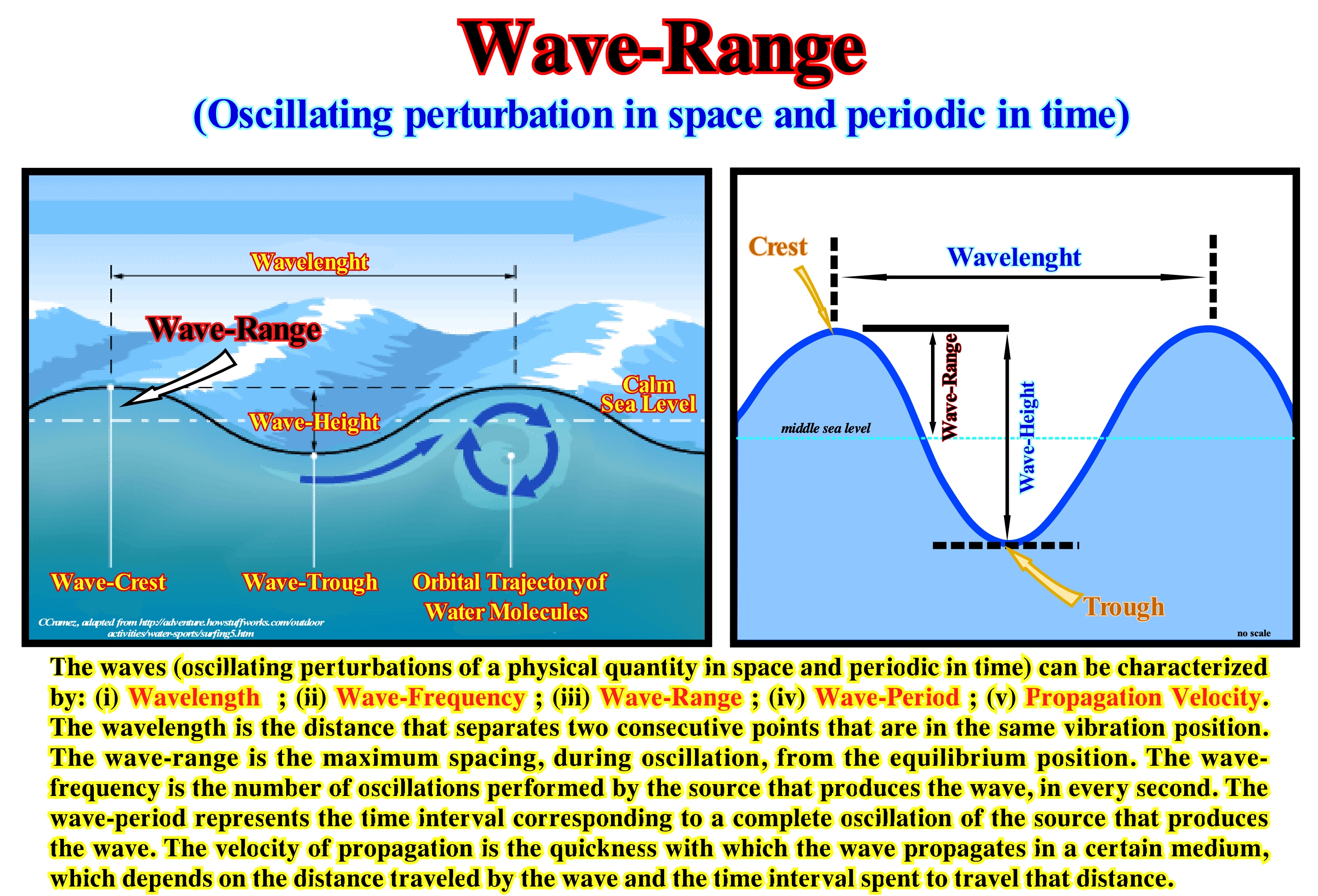
A wave is a sequence of perturbations or pulses that carry energy, in a sinusoidal manner (amplitude versus time), released by a source through a given medium. The source, which creates the disturbance of the medium, can be the fall of a rock in a lake, an underground explosion, a seismic shock created by the relative movement of faulted block fault, etc. The medium by which the kinetic energy is induced by the source can be (i) Solid, as in the case of seismic waves caused by an underground explosion ; (ii) Liquid as in the case of sea-waves or (iii) Gas, as in the case of acoustic waves. It is important not to forget that a wave does not transports matter but energy that is carried by the orbital motion of the particles that form the medium. The propagation of waves is a cycle phenomenon that can be, easily, represented by a sinusoidal curve (amplitude versus time), in which each wave (or each cycle) is characterized by the: (i) Crest, i.e., the highest part of the wave ; (ii) Trough, t he lowest part of the wave ; (iii) A wavelength i.e., the size of a wave, which can be measured between two consecutive crest or between two consecutive trough or between the beginning and end of the wave ; (iv) Amplitude, which is half the wave-height or the distance between the axis of the wave to the crest and that emphasizes the amount of energy transported (the larger the amplitude the greater the energy being transported) ; (v) Period which is the time of a complete wave, i.e., the time of passage, at the same point, of two consecutive crest or troughs ; (vi) Frequency or the number of waves, per one unit of time ; (vii) Velocity*, which underlines the distance travelled in a determining time. There are two large families of waves: (i) Mechanical waves, which need a medium to propagate, as is the case of sea-waves or sound-waves and (ii) Electromagnetic waves that do not need any medium to propagate, as for instance the light-waves and radio-waves. Taking into account the direction of propagation, the waves can be classified in: (a) Longitudinal-waves and (b) Transversal-waves. In the first the vibration of the source is parallel the direction of propagation, whereas in the second one it is perpendicular. Finally, according to the directions in which the waves propagate, they can be: A) One-dimensional, when they propagate in a single direction ; B) Two-dimensional, when propagating in two directions perpendicular and C) Three-dimensional, when propagating in all directions. Seismic waves are waves of energy traveling through the Earth. They result from earthquakes, volcanic eruptions, magma movement, significant landslides, anthropogenic explosions, etc., which release low frequency acoustic energy. These waves can be body or surface-waves. The former travel through the interior of the Earth, while the surface-waves travel only on the Earth's surface. The orbital motion of the medium particles, where the waves propagate, is greater in surface-waves than in body-waves. Consequently, surface-waves cause more damage than body waves. The velocity of propagation of seismic waves depends on the density and elasticity of the terrestrial horizons in which they propagate. The speed** increases with depth and ranges, approximately, 2,000 m/s to 8,000 m/s on the land crust, and up to 13,000 m/s in the deep Earth mantle.
(*) Velocity is a vector quantity that is fully described by both a magnitude and a direction, i.e., it is direction-aware.
(**) The speed is scalar quantity, it corresponds to the rate at which an object covers distance. Speed is ignorant of direction.
Wavelength....................................................................................................................................................................................................Longueur d'onde
Comprimento de onda / Longitud de onda / Wellenlänge / 波长短 / Длина волны / Lunghezza d'onda /
Horizontal distance between two consecutive crest or hollows of a wave.
See: « Wave Height »
&
« Breaking »
&
« Seismic Wave »
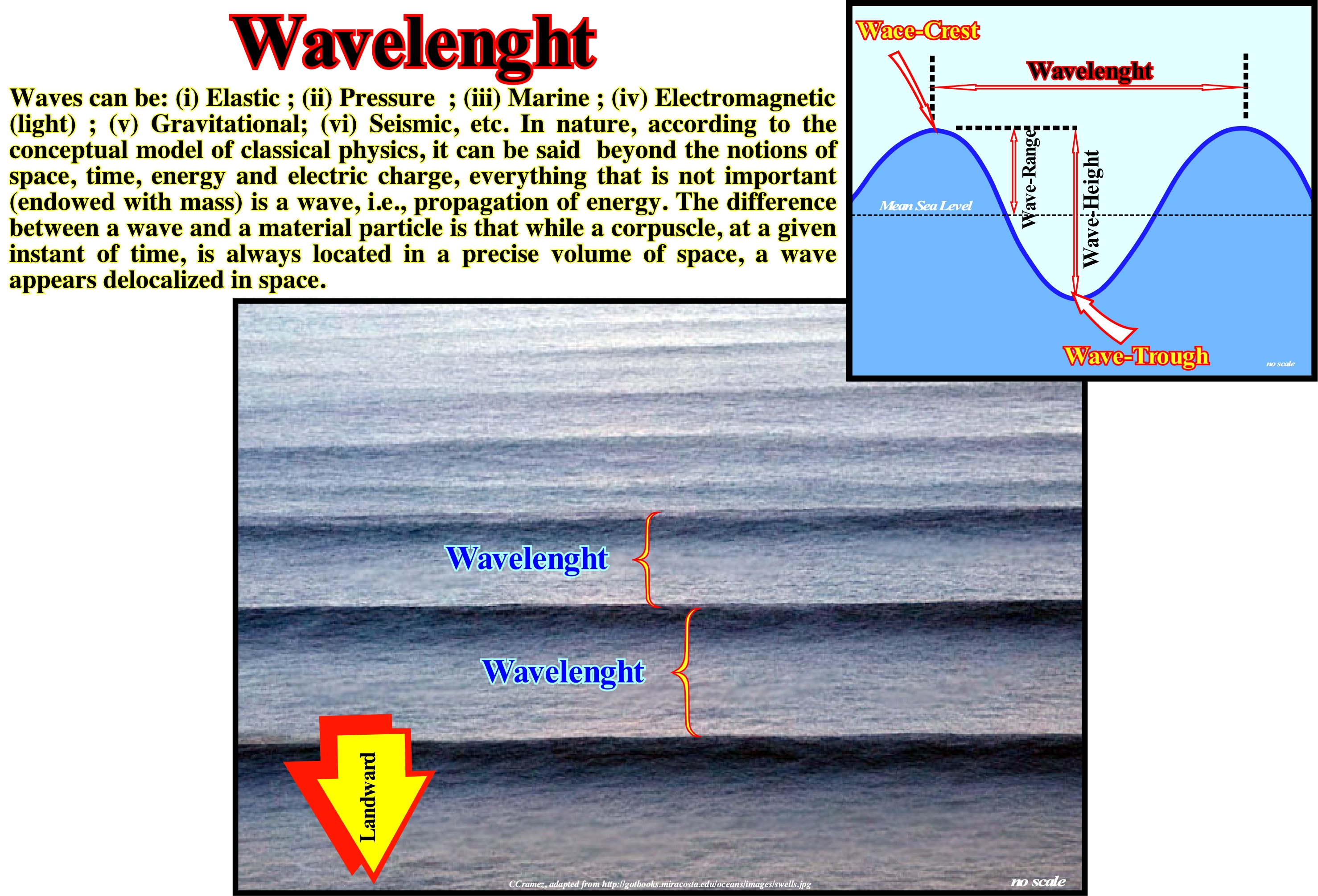
At sea, from an earthquake to the movement of a boat, everything creates waves. However, at sea, the most common cause of waves is wind. As the wind passes over the water surface, friction forces the sea to wave. The force of the wind, the fetch (distance over which the wind blows over the water) and the duration of the wind determine the size of the waves. As illustrated, waves can be divided into several parts: (i) Crest, which is the highest point of a wave ; (ii) Trough is the lowest point between two crest ; (iii) Height, i.e., the vertical distance between the crest and the next trough and (iv) Period (P), which is the time that elapses between the passing of two successive crests (or troughs) at the same point . In general, periodic waves, characterized by crests and troughs, may be transversal or longitudinal. Transversal or transverse-waves are those in which vibrations are perpendicular to the direction of propagation (waves produced by a guitar string, magnetic waves. etc.). Longitudinal-waves are those in which vibrations are parallel to the direction of wave propagation, such as, for instance, the sound-waves. When a boat, or any other object oscillates in a lake, it experiences an orbital trajectory, since waves are not simple transverse sinusoidal waves. A standing-wave is a wave that remains, steadily, in the same position. This type of wave forms when the medium travels in the opposite direction to the wave-direction. This type of wave can develop in a stationary medium when two waves move in opposite directions. As examples of waves we can mention: (a) Sea-waves ; (b) Radio-waves ; (c) Sound-waves; (d) Traffic-waves; (e) Seismic-waves (earthquakes); (f) Gravity-waves; (g) Inertia-waves, etc. The mathematical equation of these waves is, mainly, a differential equation* that describes the evolution of a harmonic wave (sinusoidal) as a function of time. The equations differ somewhat depending on the way the wave is transmitted and the medium along which it propagates. Do not forget that the velocity of a wave is, actually, a phase velocity. In sea-waves, what moves is not the water, but the crests and troughs, ti.e., the phase of the water surface. Remember that a photon (light) behaves like a wave, but since we try to observe it, it behaves with a particle**.
(*) Mathematical equation relating some function with its derivatives, i.e., an equation whose unknown is a function that appears in the equation under the formof its derivatives. In applications, the functions usually represent physical quantities, the derivatives represent their rates of change, and the differential equation defines a relationship between the two.
(**) The term particle refers, generally, to sub-atomic particles, i.e., smaller than an atom. A particle that is not formed by other smaller units, it is a fundamental particle .The particles can be matter and radiation. Particle physicists, which is dedicated to the study of particles, uses accelerators, which cause collisions between them to generate new subatomic elements.
Wearing away (Rocks)................................................................................................................................................................................................................................Usure
Desgaste / Desgaste / Abnutzung / 穿 / Изношенность / Usura /
In geology, weaaring away expresses damaged by long use, whether by corrosion, friction or abrasion. Erosion is the action of atmospheric agents, which results in the wearing away of the rocks and the transport and deposition of the detached material (sedimentary particles)
See: « Sediment »
&
« Erosion »
&
« Corrasion »
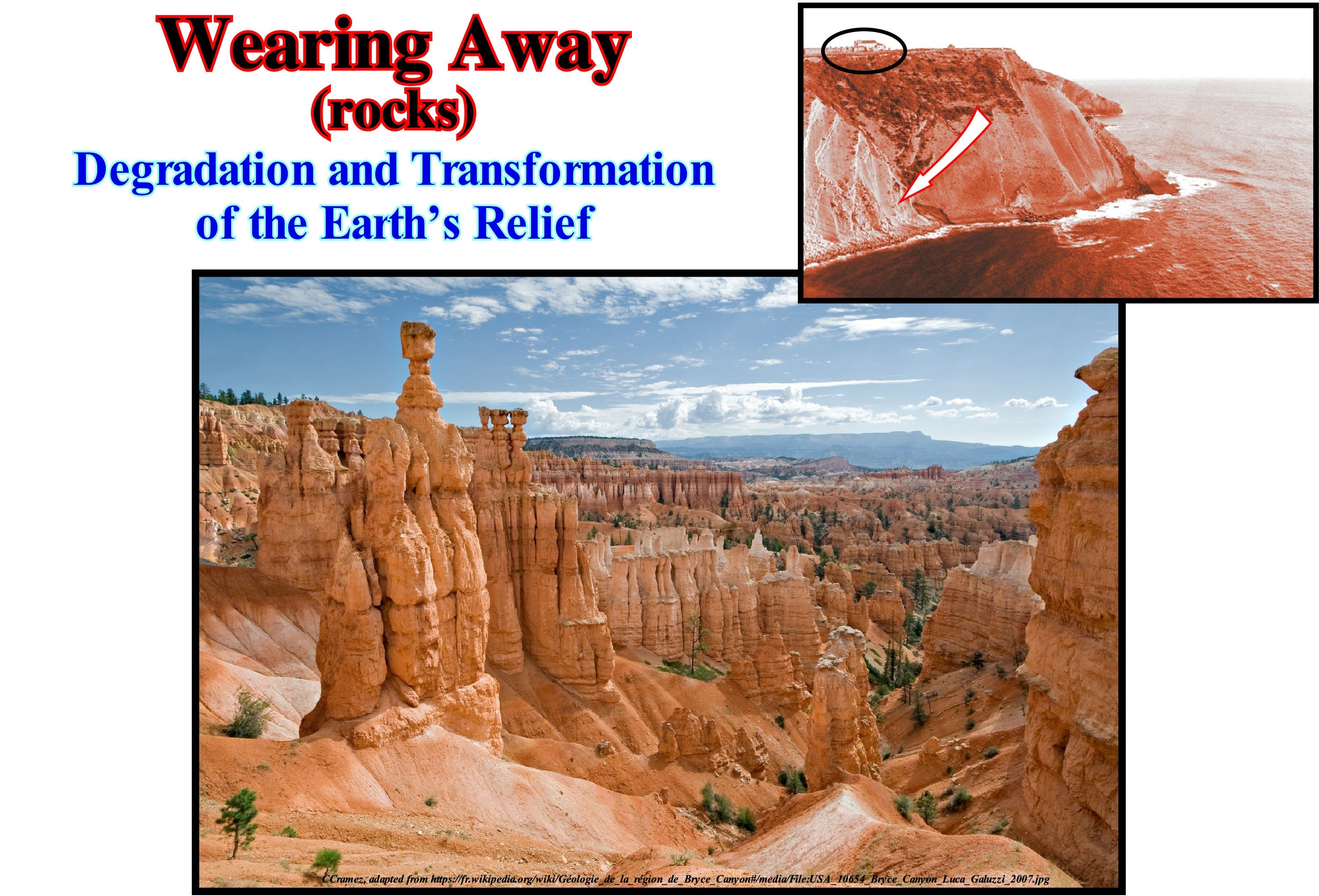
Rocks are solid bodies formed by the aggregation of mineral materials. Such bodies are formed by one or several types of minerals. All the rocks began to form in an igneous state, under high temperatures. Outside the land crust, igneous rocks are ejected through the volcanoes. The igneous material cooling, forms solid bodies of variable forms. The rocks undergo continuous processes of wear, through diverse conditions, as, weathering, storms, etc. The type of rock formed by deposition of the sedimentary particles, created by the wear agents, form the sedimentary rocks. The erosion that the original rocks (primary rocks or igneous rocks) undergo, gradually, transform them into sedimentary particles that end up being incorporated in other natural cycles (loaded by rivers, wind or rain). Over time (thousands and thousands of years), the sedimentary particles of the worn-out original rocks deposit in layers on the ground, and are pushed into the innermost parts of the Earth by the geostatic pressure (weight of the sediments). Finally, the sedimentary particles return to the environment where the rocks are in a, more or less, liquid state, melting again to restart the cycle of the rocks. Mechanical action of water and wind wears, substantially, the rocks. The movement of the waters and winds causes the accelerated wear of the rocks as it promotes their physical disintegration. These phenomena are amplified, as is the case during sandstorms in which sand, at great speed, collides with the rocks causing them to wear. Cryoclasty * is also an important process of rock wear. It is made through the infiltration of water into the cracks in the rocky massifs. When the temperature drops to negative values the water freezes and increases in volume, which exerts a great pressure on the cracks, widening them which contributes to the wear of the rocks.
(*) Fragmentation process of rocks and glaciers by the force exerted by the water that freezes inside the cracks.
Weather.........................................................................................................................................................................................................Temps (État de l'atmosphère)
Tempo (estado da atmosfera) / Tiempo (clima) / Zeit (Zustand der Atmosphäre) / 时间(大气状态)/ Время (состояние атмосферы) / Tempo (stato dell'atmosfera) /
A set of phenomena occurring in the atmosphere at a given moment. The vast majority of these phenomena occur in the troposphere, immediately below the stratosphere. Weather refers, generally, to daily temperature and precipitation in a certain region while the climate expresses average atmospheric conditions over longer or shorter periods. Do not forget that the forecasts of the weather, beyond three four days, are conjectures, few probable, advanced by the meteorologists, who have nothing to do with the climatologists.
See: « Cosmological Time »
&
« Climate »
&
« Climatology (modern) »

It is very important not to confuse weather, i.e., the state of the atmosphere at a given moment with the climate, which is a set of characteristics that define the outer conditions that reign on the Earth's surface. The cardinal parameters of the climate are the: (i) Temperature and (ii) Rainfall. These two parameters should be taken into account not on average, but in their temporal evolution. Climate is, mainly, determined by latitude. The closer we get to the poles, the more solar radiation, received by the Earth, is attenuated by the atmosphere, and the colder it is. The distribution of the continents, their surface (the distance to the sea where the clouds form) and the relief (the temperature decreases with altitude) are essential factors of the climate. We must not forget that the amount of solar energy received by the Earth varies, always, with time. The concept of climate is very fashionable. Some geoscientists suspect (perhaps rightly) human activity has a decisive influence on the climate and so many people would like to know what to do to prevent a possible catastrophic climate change. Recently, the study of climate has been, strongly, stimulated by the study of the climate of the geological past, which is the object of paleoclimatology*, which shows, in a difficult refutable way, that CO2 contents fluctuated a lot in the geological past. In addition, they suggest the CO2 content followed an increase in temperature of the oceans rather than the inverse. So, probably, and contrariwise to the Al Gore's "certainties", it is the increase in temperature and, above all, the increase in the temperature of the oceans that induces an increase in the CO2 content in the atmosphere. Do not forget, the oceans contain about 60 times more carbon in the form of dissolved inorganic carbon than in the pre-anthropogenic atmosphere* (± 600 1015 g C). At time scales <105 years, the oceans are the largest reservoir of inorganic carbon (± 38,000 1015 g C) in exchanges with atmospheric carbon dioxide (CO2) and as a result, the ocean exerts a dominant control over CO2 levels atmospheric. The average inorganic carbon concentration in the ocean is ± 2.3 mmol kg-1 and its residence time is ± 200 ka. The CO2 dissolved in the ocean occurs, mainly, in three inorganic forms: (i) Free aqueous carbon dioxide (CO2, aq) ; (ii) Bicarbonate (HCO3-) and (iii) Carbonate ion (CO3-). A smaller form is the true carbonic acid H2CO3 whose concentration is less than 0.3% of CO2 (aq). The sum of CO2 (aq) and H2CO3 is denoted by [CO2]. Most of the inorganic carbon dissolved in the modern ocean is in the form of HCO3- (> 85%). (https://www.soest.hawaii. edu/ oceanography/faculty/zeebe_files/Publications/ZeebeWolfEnclp07.pdf). As the solubility of CO2 decreases with temperature (http://www. engineeringtoolbox.com/ gases-solubility- water-d_1148.html), if the temperature of the oceans increases the amount of CO2 in the atmosphere increases. The climate has a very important influence in the sequential stratigraphy, in particular in the creation and variation of the available space for the sediments (particularly shelfal accommodation) by glacio-eustasy (see below). However notice that during the thawing of the ice caps (not salty ice bodies)**, in response to the load of additional water, the ocean level is depressed and in response to the charge removed (where the ice caps melted), the continent will be uplifted. Redistribution of material within the Earth is affected by overload and will further strain ocean surface variations (induced by gravity anomalies), and thus further redistributions of water will be required to attempt to equalize gravitational potential. This continuous retroactive gravitational process between the ice caps, oceans and the continent is the process that, finally, determines the relative sea level, which is observed everywhere the continent and the ocean meet. It should be remembered that in sequential stratigraphy, sea level can be of two types: (i) Relative sea level, which is a local sea level, referenced to any fixed point on the Earth's surface, which can be the base of the sediments or the sea floor and (ii) Absolute or eustatic sea level, which is supposed to be the global (see previous paragraph), referenced to the Earth's centre. The relative sea level is the result of the combined action of absolute (eustatic) sea level and tectonics (subsidence or uplift of the sea floor). The absolute sea level is the result of the combination of: i) Tectono-Eustasy that is controlled by the volume variation of the ocean basins in association with oceanic expansion following the break-up of the supercontinents ; (ii) Glacio-Eustasy, which is controlled by the variation of water volume of the oceans as a function of the amount of ice (assuming that the amount of water in all its forms is constant since the formation of the Earth, there are about 4.5 Ga); (iii) Geoidal-Eustasy which is controlled by the distribution of ocean water caused by variations in the Earth's gravity field (where gravity is stronger than normal, sea level is thrown to the centre of the Earth) and (iv) Steric sea level rise or thermal expansion of the oceans (if the temperature increases, the density of the water decreases, and for a constant mass, the volume increases).
(*) Take into account both the duration and the magnitude of the climate changes, several geoscientists proposed the following hierarchization : (i) Pulsations, that last a few years or a few decades and which are perfectly reversible (e.g., series of years of raining or drought) ; (ii) Oscillations, that last from a few centuries to a few millennia, but are reversible (e.g., the Little Ice Age) ; (iii) The Fluctuations, that are spread out over tens, hundreds of thousands of years and have mark cyclic character (e.g., the evolution of the Quaternary) ; (iv) Mutations, that lasted millions, tens or hundreds of millions of years that have a irreversible character (e.g., irreversible upheavals of the Earth’s surface).
(**) Take into account that when salt water starts to freeze, water molecules start arranging themselves in a regular configuration, expelling the salt molecules into the water that has yet to freeze. When the salt content in the remaining water gets too high, salt crystals will form. When the salt water on the surface of the Arctic Ocean start to freeze, due to the colder air, it frees into pure ice (not salty ice) expelling the excess salt into the ocean below. In an inlandsis, i.e., is a very large glacier in the form of an ice sheet covering the mainland(presently there are only two of them : the Antarctic ice sheet, the largest, and the Greenland ice sheet) the ice is made from compacted snow, which formation is the same as rain: water condenses onto a speck of dust high up in the atmosphere. This makes snow and rain necessarily non-salty. (https://www.quora.com/Why-does-sea-water-have-salt-in-it-but-ice-in-polar-ice-caps-have-fresh-water)
Weathering..........................................................................................................................................................................Météorisation, Altération
Meteorização (altderação) / Meteorización / Verwitterung / 風化 / Вывéтривание / Meteorizzazione /
Decomposition of rocks, soils and their minerals by direct contact with the Earth's atmosphere. Weathering occurs in the site, without movement and thus can not be confused with erosion, which involves movement and disintegration of rocks and minerals by erosive agents such as water, ice, wind, gravity, etc.
See: « Palasome (mineral) »
&
« Diagenesis »
&
« Rock Cycle »

In this photograph, the effects of weathering can be observed without great difficulty. During the weathering process, hard and tough material is left in place, while the less resistant material is weathered by wind and water. Mechanical weathering is the cause of rock disintegration. The main process of mechanical weathering is abrasion (the process by which clasts and other particles are reduced in size). Chemical and physical weathering, often, acts in association with mechanical weathering. Fractures struck by mechanical weathering increase the surface area of exposure to chemical agents. The chemical action on the minerals in the fractures helps the processes of disintegration. This happens, for instance, when the water from the sea-waves of an agitated sea is injected into the fractures of a rocky wall. Such injection of water compresses the air at the bottom of the fracture against the rock weakening it, substantially. Since the wave is withdrawn (backwash current, for example), the air that has been compressed at the bottom of the fracture is, quickly, released with an explosive force. This explosive release of air, highly, pressurized splinter fragments of the rocky wall thus widening the fractures. In the coastal zone, there is a very interesting type of weathering, which some geoscientists call haloclasty. Indeed, as its name suggests, this type of weathering is caused by the crystallization of salt, which, progressively, disintegrates the rocks. When salts solutions enter the fractures and then evaporate, they leave the salt crystals. These crystals when heated by sunlight dilate exerting a great pressure against the rock. The crystallization of the salt can also be made from solutions, which attack the rock, and which form salt solutions of sulphate or sodium carbonate, which evaporate and deposit salt.
Wilson's Cycle................................................................................................................................................................................................Cycle de Wilson
Ciclo de Wilson / Ciclo de Wilson / Wilson-Zyklus / 威尔逊旋回 / Цикл Уилсона / Ciclo di Wilson
Opening and closing of ocean basins due to plate tectonics. In a Wilson cycle, the following tectonico-stratigraphic phases can be recognized: (i) Stable Continental Craton; (2) Thermal Anomaly and Lengthening ; (3) Lithosphere Breakup ; (4) Ocean Expansion (sea floor spreading) ; (5) Subduction ; (6) Divergent Margin/Volcanic Arc collision forming mountain chain ; (7) Peneplanation and Subduction ; (8) Continent/Continent collision and (9) End of the Wilson cycle with the formation of a new Stable Continental Craton.
See :« Supercontinent »
&
« B-Type Subduction (Benioff) »
&
« A-Type Subduction (Ampferer) »

The Wilson cycle, proposed by Tuzo Wilson, explains in an orderly way the process of opening and closing of oceans, as well as, the fragmentation and subsequent formation of the supercontinents. The Wilson cycle causes the formation of mountain belts and summarizes everything that happens on the continental (divergent) or convergent (or destructive) continental banks of the lithosphere. In a Wilson cycle, the following steps can be highlighted: (i) Stable Continental Craton, such as the Precambrian supercontinent Protopangea or Rodhinia (from the Russian "rodit" which means to create or to grow) ; (3) Breakup of the Lithosphere, with the creation of new volcanic crust (subaerial and oceanic) and formation of two lithospheric plates ; (4) Oceanic expansion (sea floor spreading), which, progressively, transforms the young margins into old margins due to cooling and increasing density of the oceanic crust ; (5) Subduction, that is, diving of one of the lithospheric plate (descending plate) under the other overriding plate (when the density of the oceanic crust is very high, it splits in two portions and one of them dives under the other) creating a convergent margin, with the formation a volcanic arc and the uplift of a mountains belt in the overriding plate ; (6) Divergent Margin / Volcanic Arc Collision, formed by a mountain belt, while, at the other end of the plate there is the twin divergent margin ; (7) Peneplanation of the mountain belt and new subduction of the oceanic crust with the twin margin creating another convergent margin ; (8) Collision Continent / Continent and closure of the ocean created between the two initial divergent margins and (9) Formation of a new Stable Continental Craton, i.e., the end of the Wilson cycle. This geological model reasonably explains the aggregation and fragmentation of the supercontinents (Proto-Pangea or Rodhinia at the end of the Precambrian and Pangea at the end of the Paleozoic). It explains, also, the 1st order T / R cycles associated with absolute (eustatic) sea level changes. Assuming that the amount of water (in all its forms) has been constant, since the Earth's formation (around 4.5 Ga), it is easy to understand that the global sea level is higher when the oceanic expansions are predominant (ocean basin volume decreases due to the formation and volume of oceanic ridges), and that it is lower, when the continents aggregate to form a supercontinent (the volume of the basins is maximum, since the volume of the ocean ridges is minimal). The higher order T / R cycles, i.e., 2nd and 3rd order imply geological factors other than the volume changes of the ocean basins. As the Wilson cycle is based on the plate tectonics theory, let us remember that: (A) The outer and rigid layer of the Earth, i.e., the lithosphere is a mosaic of tectonic plates that move relative to each other, with speeds of the order of a few centimeters per year (speed of growth of the nails of humans) ; (B) The plates are born at the level of the mid-oceanic ridge and they float on a plastic and warm layer of mantle called asthenosphere ; (C) The plates move away without deformation and their movement is, directly, connected to the sea floor spreading (oceanic expansion), in which the hot and melted material of the asthenosphere rises through the lithosphere to the top of the oceanic mountains (mid-oceanic dorsal) where, by cooling, it forms the oceanic crust ; (D) The new oceanic crust moves,continually, away from the axis of the mid-oceanic ridge and, as it approaches the continents, the plates are destroyed in the ocean trenches along the Benioff subduction zones (B-Type subduction), plunging into the mantle ; (E) The continents are, generally, regarded as passive objects carried by the sea floor spreading spread, however they do not remain, completely, immune to the tectonic mechanisms of the plates) ; (F) The continents (continental crust blocks) can collide and create large continents ; (G) Plate boundaries consist of ridges areas, subduction zones and transforming faults ; (H) The internal energy of the globe dissipates in the limits of the plates and the dissipation is mechanical (earthquakes, formation of the mountain, etc.) or thermal (plutons, volcanoes, etc.) ; (I) Relative motions of the plates are governed by the mathematical laws of kinematics on a sphere (the relative motion of two rigid spherical shells is, completely, described when one knows the pole of rotation, Euler pole, and the angular velocity).
Wind-Scoured Basin.......................................................................................................................................................Bassin de déflation
Bacia por déflação / Cuenca por deflación / Wind-Becken gescheuert / 风冲刷盆地 / Котловина выдувания / Por deflazione bacino /
Depression, relatively small, formed by wind erosion of little or nonconsolidated sediments.
See: « Deflation »
&
« Basin (sedimentar) »
&
« Depositional Environment »

The photograph at the top right of this figure illustrates a wind-scoured basin formed in the floodplain of the Wisconsin River (Spring Green, USA). The genesis of this basin, as well as that of the vast majority of wind-scoured basins, is schematised in the block diagram. The formation mechanism can be summarized as follows: (i) Wind turbulence, erodes, calibrates and transports the loose sedimentary particles to a depositional lobe, and (ii) Formation of a depression (wind-scoured basin), in which, sometimes, in the deepest part, a lake forms, as illustrated above. The location and geometry of the depositional lobe, in relation to the wind-scoured basin, indicates the amplitude and direction of the wind. A wind-scoured basin can be defined as a topographic basin excavated and maintained by the erosive action of the wind, which removes the poorly consolidated material, usually, leaving around the rocks more resistant. Although this type of basin is formed mainly in arid or semiarid areas, it can be found in other sedimentary environments. A shallow lake may occupy the central part of the basin during certain seasons (lake of wind-score basin). An important feature of these basins is that they are closed and shallow. A wind-scoured basin can collect water or intersect at its bottom a groundwater level. The term basin is used,only, when the dimensions of these depressions exceed tens of meters with a depth greater than 2-3 meters. In other cases, it is better to speak of wind-scoured cavities. As in the case of a point-bar (simultaneous erosion and deposition), it is evident that the erosion caused by the wind does not creates to an unconformity (in the sense that this term is used in the sequential stratigraphy), since erosion is local and coeval of the formation of the deposition lobe. This type of basin is, entirely, independent of relative sea level changes. Basins similar to a wind-scoured basin can form in association with snow. In snow-covered alpine regions, the location of wind-scoured basin is very important for understanding avalanches, water sources (small scale) and climate.
Windward Platform Margin............................................................................................Marge de la plate-forme (Au vent)
Margem de plataforma (barlavento) / Márgen de plataforma (barlovento) / Margin-Plattform (der Wind) / 保证金平台(风) / Окраина платформы (против ветра) / Piattaforma di margine sopravvento /
Margin of a carbonated platform facing the dominant wind. Certain carbonated platforms as the Bahamian platforms, show that prevailing winds have a significant effect on cross-bank sediment transport and platform margin geometries. In general, windward margins are reef dominated with aggradational geometries, and leeward margins are carbonate sand and mud dominated with progradational geometries. Platforms that are close to a continental mass and whose origin is the existence of this mass are considered margins or ramps. When carbonate deposits are surrounded on all sides by water they are called banks, shoals or isolated carbonated platforms.
See: « Rimmed Reef Platform »
&
« Reef »
&
« Deposition (carbonates) »
The carbonate platforms, which are not connected to the continent, present very important variations not only in the geometry, but also in the facies (lithology and fauna), as a function of the surrounding oceanographic conditions. A number of studies, particularly those conducted in the Caribbean Sea, have shown there is a big difference between the windward carbonated margin (side of the platform receiving the wind or side where the wind blows) and the leeward carbonated margin (opposite the side where the wind blows). The dynamics and preservation of the sediments is very different if the carbonate margin faces the wind (windward margin) or if it is oriented towards the wind (leeward margin). The former have a, relatively, weak terrigeneous influx, since the sedimentary particles are, largely, transported to the platform, that is, in the opposite direction of the margin. In strong energy conditions, the windward margin is, significantly, eroded to form a steep escarpment at the base of which rocky blocks and debris flows are deposited, as suggested in the sketch illustrated in this figure. On the contrary, in the leeward margins, that is to say, in the margins oriented towards the prevailing winds, the sedimentary intervals are progradational, thick and of more important lateral extension. The windward carbonate margins that face the energy of the waves and are exposed to the dilating effect of the sea may be protected by islands or emerging reefs. The water does not behave like most liquids thermally, which has very important consequences in nature. Imagine that a certain amount of water at 0° C is placed in a nonswellable container and that temperature is increased: (i) the volume of the liquid decreases until the temperature reaches 4° C (water shrinks) ; (ii) From there, if the heating continues, the volume of the liquid increases (the water undergoes a dilation). Let us suppose that, at a given moment, the air temperature begins to drop (from 18° C, for example). The surface water, in contact with the air, cools and becomes denser than the bottom water. This difference in density causes the movement of water: hot water rises and cold water descends. However, when the temperature reaches 4° C, this movement ceases, because at this temperature, the water has maximum density. If the cooling continues, the surface water will be less dense than the bottom water, and the position change is no longer possible. Surface water may freeze, but bottom water remains liquid. Ice (solid water phase) floats on liquid water*. Cooling of bottom water occurs very slowly because both liquid water and ice poorly conducting heat. This is why the (https://en.wikipedia.org/wiki/water_animation_dilation). With regard to sediment transport, at the windward margins, consideration must be given to the presence or absence of significant barriers to sedimentary transport. At the open carbonated margins, wave-induced currents can move detrital sedimentary particles from the windward reefs to the platform. In contrast, sediments produced on protected margins can be incorporated into reefs, stored in areas between reefs, or transported offshore by wind. There are five categories of carbonated platforms: (i) Rimmed Platforms , characterized by the presence of reefs or calcareous sand of fallow in the platform edge and clay sands in the lagoon or the open platform ; (ii) Platforms Type Ramp type, in which the carbonated sands of the shoreline pass at the base of the ramp to clay sands and deep-water mud; (iii) Epeirial (or epíric) Platforms, characterized by the presence of tidal surfaces and protected lagoons ; (iv) Isolated Platforms, in which facies are controlled by the orientation of the prevailing winds and (v) Drowned Platforms, when they are under the photic zone. The platforms connected to the continent are divided into two large families: (1) Ramp Type and (2) Top-Flatened Type. In ramp type platforms two subtypes can be considered: (1.1) Monoclinal and (1.2) Distal Steepened. In top-flattened platforms there are also two subtypes: (2.1) Nonrimmed and (2.2) Rimmed. It is in the subtype (rimmed platform) that the designation of abrupt carbonated platform is more frequent. The absence of a barrier, such as that on the rimmed platform, is the result of a high energy that creates complex coastal lithologies with a high rate of sedimentary transport. Although barrier reefs are absent, reefs pinnacles and reef mounds can be found on nonrimmed platforms. Modern rimmed platforms are found mainly on the tropical coast of the Arabian Gulf, Shark's Bay (Western Australia) and Yucatan (eastern part). The carbonated platform illustrated in the photograph of this figure is probably a ramp-type platform of the monoclinal subtype. According to some geoscientists, this type of platform seems to be more frequent when the processes of carbonate manufacture are of cold water. When carbonate manufacturing processes are associated with tropical climates, carbonate platforms are, usually, either rimmed or nonrimmed, or they correspond to mounds of mud with a edge not evident.
(*) Ice is less dense than water because the orientation of hydrogen bonds causes molecules to push farther apart, which lowers the density. Because ice is less dense than water, it is able to float at the surface of water. For most substances, th increasing the space between molecules, making warmer liquids less dense than cooler solids.
Winter Accumulation (Varve)............................................................................................................Accumulation Hivernale
Acumulação invernal (de uma varva)/ Acumulación invernal / Winter Anreicherung / 冬季積累 / Зимнее накопление / Accumulo di inverno (a varva) /
Deposition of shaly sediments at the bottom of a proglacial lake during the winter, when the distributive channels are frozen and, therefore, they can not transport new sediments to the lake.
See: " Varve "
&
" Summer Accumulation "
&
" Proglacial Lake "
The varves are common sedimentary rocks formed by thin sedimentary layers deposited, seasonally, in the bottom of the lakes. The varves have a typical laminar structure, in which clear sandy or shaly sediments, formed in the summer, alternate with dark shaly sediments, formed in the winter. When the lake is of the glacial type, the varves are denominated glacio-lacustrine. This figure shows the glacio-lacustrine varves deposited near the Little River (Vermont, USA). Each pair of layers represents the pattern deposited annually in a water-body (usually a proglacial lake). The annual variations of the water flow condition the terrigeneous influx into the water-bodies. The coarser sedimentar particles are transported during the summer and deposit rapidly, whereas the finer particles take several months to deposit and accumulate, generally, in winter, when the distributive channels are frozen. The different sizes and compositions of the particles produce a zebra pattern, which the seasonal variations accentuate, since the amount of organic matter (dark colour) deposited is more important during the winter than during the summer. Clear and coarser horizons deposit during the summer and pass, vertically, to darker horizons, of finer granulometry than the sediments deposited during the winter. This pair of sedimentary horizons represents the record of one year of deposition. A similar sedimentary process occurs, also, in the formation of glaciers and ice caps, since these are deposited in layers (the most recent ones covering the oldest ones). Ice caps are estimated to have more than 100,000 ice sheets. In these layers, there are pollen, which allows to advance hypotheses about the vegetation cover at a given time, as well as, air bubbles that can give indications about the composition of the Earth's atmosphere (in particular, about the CO2 content) at different glacial epochs. However, certain geoscientists, who study the gases contained in the ice air bubbles and claim that the results are stable, forget, sometimes, how these bubbles are formed. The gas bubbles move in the snow and firn above the closure zone (between 20 and 150 m depth). During the opening period of gas bubbles, which may be over 5,000 years, there is aggregation by convection, diffusion and gravitation of the atmospheric gases. In other words, gases are, more or less, in communication with the atmosphere, which implies, necessarily, a weighting* (an mean average) of the results over several millennia. When the weighting is not done, the results of the CO2 content, for example, measured in the ice cores are very homogeneous when compared to the indirect results of the temperature given by a "proxy" **. Geoscientists, such as Jean Laherrere, that point out the influence of atmospheric contamination (± 5,000 years) on the gas bubbles of the ice cores and thus on temperature determination, continue to be treated as sceptical by the "new" ecologists who defend or defended anthropogenic global warming dogmatically and unscientifically.
(*) Statistical technique in which a data item (such as an average) is emphasized more than other data items comprising a group or summary. A number (weight) is assigned to each data item that reflects its relative importance based on the objective of the data collection (http://www.businessdictionary.com/definition /weighting.html) A statistical weight is an amount given to increase or decreased the importance of an item. For example, weights are commonly given for tests and exams in class. For example, a final exam might count for double the points (double the “weight”) of an inclass test. A weighting factor is a weight given to a data point to assign it a lighter, or heavier, importance in a group. It is usually used for calculating a weightened mean, to give less (or more) importance to group members. It is also used in statistical sampling for adjusting samples (https://www.statisticshowto. datasciencecentral.com/weighting-factor/)
(**) It is a variable that in itself does not have much interest, but from which one can obtain another variable much more interesting. For this to be possible, the proxy variable must have a strong correlation, but not necessarily linear or positive, with the inferred value. However, it has no value if the data (represented in a cloud of certainty) do not fit in any relation. Paleoclimatology, for example, studies climate changes at the scale of Earth's history, measuring proxies, which correlate with paleoclimate variables and then infer the values of paleoclimate variables, since they can not be measured directly. This is particularly true for sea level changes, which can be inferred from sequential stratigraphy studies, especially when it is done on regional seismic data (preferably in depth) and calibrated by oil exploration or scientific wells.
Winnowed* Turbidite.....................................................................................................................................................Turbidite tronquée
Turbidite truncado / Turbidita truncada / Turbidit abgeschnitten / 风选的浊流沉积 / Усечённый турбидит / Torbiditici troncato /
Submarine fans (SBFF or SSF) eroded by deep-sea or gravity currents. During lowstand geological conditions (sea level below the basin edge), as the frequency of gravity and deep sea currents increases, significantly, contour currents, which can erode submarine basin floor fans and and redistribute the eroded material as contourite deposits.
See: « Submarine Basin Floor Fan »
&
“ Submarine Slope Fan ”
&
« Lowstand Systems Tract »
Prior to the 1950s, the term turbidite was, generally, used to designate a metric fining upward bed (impossible to bring to light on a seismic line) formed by a set of sandstone and shaly layers deposited by a turbidity current and covered, usually, by hemipelagic shales containing deep-water fossils. Such a term was used, mainly, to designate sedimentary deposits, sometimes, very thick, originated by submarine gravity currents, in foredeep basins i.e., in a tectonic setting of convergent continental margins. Kuenen and Migliorini (1950) interpreted the graded bedding observed in the old flysch deposits as the result of turbidity currents. About 40 years after the first proposed geological models for submarine fans (Normark, 1970, Mutti and Ricci Lucchi, 1972), the number of models (often mixing data derived from subsurface and outcrops) approached the number of turbidites studied (a situation anticipated by Normark in 1993). For the geoscientists working in petroleum companies, this situation can be explained by the fact that prior to the advent of seismic stratigraphy, most of the knowledge about turbidites was the result of field studies of deep-sea sequences deposited in old episutural and perisutural basins. Currently, geoscientists consider two basic models to explain turbidite deposits. The model of Emiliamo Mutti, which was, basically, constructed on field data (mesoscopic scale), and the model of Peter Vail, which was constructed, mainly, using seismic data (macroscopic scale). In E. Mutti model, the study of turbidite facies is fundamental, while in the P. Vail model (seismostratigraphy) the recognition of significant relative sea level falls** and the identification of the unconformities (erosional surfaces) is paramount. The North Sea, where the seismic line of this Canvas auto-trace was shot, corresponds to the stacking of several sedimentary basins of Bally and Snelson (1980) basins' classification. Over a basement, which may, locally, correspond to a, more or less, Paleozoic flattened mountain belt, rift-type basins were developed, which are overlain by a cratonic basin. The boundary between the rift-type basins and the cratonic basin corresponds to an unconformity that marks, above all, the change from a differential to a thermal subsidence. On the tentative geological interpretation of the Canvas auto-trace of a detail of a North Sea seismic line, depicted above, truncated (winnowed) submarine fans (P. Vail terminology), probably submarine slope fans SSF) are illustrated. This turbidite interval rests, directly, on an unconformity induced by a relative sea level fall which has brought the sea level lower than the basin edge. Such a turbidite interval is, perfectly, fossilized by the lowstand prograding wedge (LPW) of the same or posterior sequence-cycles. The internal configuration is, more or less, wavy and taking into account the dip of the unconformity between the rift-type basins and the cratonic basin, it can be said that at the time of deposition the reflectors were, practically, sub-horizontal. As is, clearly, seen on this tentative, certain reflection terminations (lapouts) of the top of the turbidite interval strongly an erosional seismic surface. If that is true, one can speak of truncated turbidites (winnowed turbidites for certain geoscientists). In fact, it may be assumed that a large part of the material of the submarine fans was, probably, eroded by contour currents and redistributed by these same currents, which flow parallel to the continental slope. The material carried by the contour currents was deposited in the form of contourites, not far from the submarine fans. As seen in other tentative geological interpretations of seismic lines of this area, unlike the submarine basin floor fans (SBFF), the internal configuration of the intervals interpreted as contourites is parallel, but the reflectors are dipping more than 10° eastward. Note, that the efficiency of the contour currents is contested by certain geoscientists: (i) Draining at a speed of about 20 cm/s, are they energetic enough to construct such thick intervals? and ii) How the sedimentary particles enter in the contour? It is most likely that most of the material is, originally, carried by the gravity currents and that another part is the result of erosion induced of the submarine fans by these same currents.
(*) The term winnowed turbidite seems be to be inadequate since the wind or air currents are inoperative in submarine environments, in which the submarine slope and basins floor fans are deposited. We prefer truncated turbidite.
(**) Combined action of absolute (eustatic) sea level and tectonics, i.e., subsidence or uplift of the sea floor depending on the predominant tectonic regime (extensional, i.e., lengthening of the sediments, in the first case and compressional, i.e., shortening of the sediments, in the case of uplift).
Würm (Glaciation).....................................................................................................................................................................................................Würm (Glaciation)
Glaciação de Würm / Würm (Último periodo glacial) / Würm-Kaltzeit / 末次冰期 / Последняя ледниковая эпоха / Glaciazione Würm /
Pleistocene last global glaciation in the Alps. The definition of this glaciation was based on observations of the geological consequences of significant fall of the average temperature*, over a, more or less, long time period, in the alpine massif.
See: « Glacio-Eustasy »
&
« Moreia »
&
« Incised Valley »
This map represents the extent of ice (in light grey, yellow arrow) during the last glacial period known as the of Würm or Wisconsian Glaciation, which occurred about 20,000 years ago and lasted for several thousand years. The Würm (or Laurentian) glaciation corresponds approximately to phases 2, 3, 4 and 5a-d of the isotopic chronology developed since the 1950s. Its lower limit is, generally, fixed at 115 k before Christ (beginning of phase 5d), but certain geoscientists consider that it began with phase 4 (about 75 k before Christ). Its upper boundary corresponds to the end of phase 2 at the beginning of the Holocene (period of the Quaternary of the Cenozoic era of the Phanerozoic, which began about 11,500 years ago and extends to the Anthropocene**, in which all life forms we know are present, especially humans), i.e. about 10 k years ago. The glacial acme was reached about 20 ka, when the temperature began to increase in the Northern Hemisphere (above 60 ° latitude), due to a slight orbital change that approached the Earth from the Sun in the borealis summer. In addition, the axis of rotation is inclined so that the northern hemisphere enjoys the first excess of insolation. The Würm glaciation is, more or less, synchronous with other glaciations in the Northern Hemisphere, such as the Wisconsian glaciation in North America, the Weichselian in Northern Europe and the Devensian in the British Isles. The Würm glaciation has a local chronological significance, limited to the Alpine region. The Würm glaciation is a manifestation of a cooling that affected, more or less, directly the whole Earth. This cooling had as a consequence a fall of the absolute (eustatic) sea level around 100 meters (assuming that the amount of water in all its forms is constant since the Earth's formation, i.e., more or less, 4.5 Ga) and the establishment of a periglacial climate in Europe, which has led to profound changes in fauna and flora. The eustatic fall is well visible on seismic data, particularly, in offshore seismic lines, as the coastal deposits have moved seaward and downward causing exhumation of the shelves, in particular between 50 and 40 ka and later, between 25 ka and 12 ka. Emerging regions include: (i) Beringia (thee Bering Terrestrial Bridge), which is a portion of land with approximately 1,600 kilometers from north to south at its maximum extent joined Alaska and Siberia during the glaciations (located where, today, is Strait of Bering) ; (ii) Terrestrial bridges between Australia, Tasmania and New Guinea, forming a large continent called Sahul (other than Australia being separated from Papua New Guinea by the Torres Strait and Tasmania by the Bass Strait, these three masses of land, which are intimately related from the biological, geological and anthropological point of view, are the parts that emerge from the same continental shelf) ; (iii) Inland bridges between the Philippine and Indonesian archipelagos ; (iv) The region between Japan and Korea. The maximum extent of ice caps and ice seas (north and south hemispheres) during the last ice age are currently, relatively, well known. Its maximum range of expansion was reached approximately at the same time, more or less, at 19 ka, and then the ice began to melt. Simultaneous melting was, probably, caused by a global rise in absolute (eustatic) sea level and by changes in the circulation of deepwaters in the Atlantic Ocean, which transported warmer water to the Antarctic continental margin. The retrogradation of the Antarctic ice cap, which is, today, about 450 km (± 24 m per year), heavily contributed to the ± 130 meters of absolute sea level rise (post-glaciation). The contribution of the ice seas is nil. The water is denser than ice. The glacio-eustasy, considered, sometimes, global and uniform can not be either global or uniform, since any significant variation in absolute sea level affects, also, the terrestrial geoid. Indeed, during the thaw, in response to the load of water added to the ocean basins, the absolute sea level will be depressed, and in response to the load removed, the continent will be lifted. Redistribution of material within the Earth is affected by overload and will further force variations of the surface of the ocean (induced by gravity anomalies), and thus further redistributions of water will be required to attempt to equalize gravitational potential.
(*) In climatologgy an average temperature or an average of sea level to have meaning it must cover a rather long period. The World Meteorological Organization (WMO) recommends that it must cover, at least, 30 (thrity) years: from there one can speak of « normal »
(**) After the Pleistocene, which opened the Quaternary there are ± 2.5 Ma, and the Holocene, which began ± 11,500 years ago, it seems appropriate to name Anthropocene the present geological epoch, dominated in many ways by Human Action (Paul J. Crutzen, 2002, Geology of Mankind, Nature, 415, Jan. 3, pp.23). Several dates have been advanced for the beginning of the Anthropocene, i.e., as soon as Humanity became, without realizing it, an important geological agent. however, on this subject, there is no consensus. On the contra, everybody agree the Anthropocene is the product of a generalized growth of the population, of agriculture , industry, deforestation, mining, GDP, etc.

Send E-mails to carloscramez@gmail.com or to carlos.cramez@bluewin.ch with comments and suggestions to improve this glossary.
Copyright © 2009 CCramez, Switzerland
Last updated: September, 2019
